Medveđa elevation
Medveđa (Central Serbia, Jablanica), Serbia elevation is 367 meters and Medveđa elevation in feet is 1204 ft above sea level [src 1]. Medveđa is a seat of a third-order administrative division (feature code) with elevation that is 200 meters (656 ft) bigger than average city elevation in Serbia.
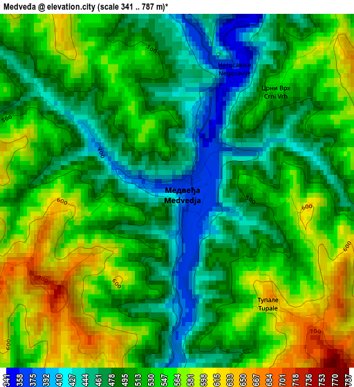
Below is the Elevation map of Medveđa, which displays elevation range with different colors. Scale of the first map is from 341 to 787 m (1119 to 2582 ft) with average elevation of 517.7 meters (=1698 ft) [note 1]
These maps also provides idea of topography and contour of this city, they are displayed at different zoom levels. More info about maps, scale and edge coordinates you can find below images.
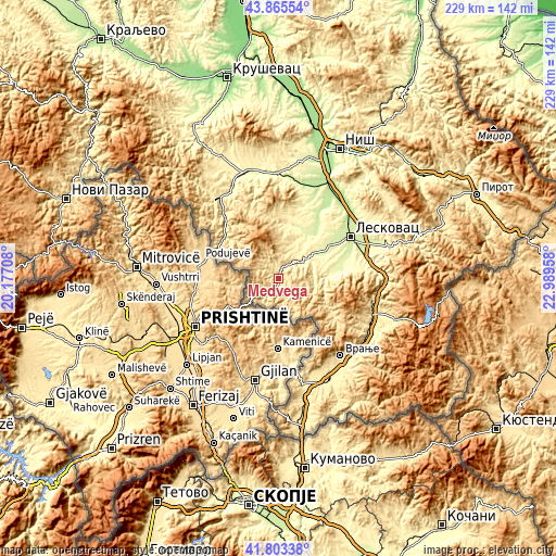
| \ | Map #1 | Topo.Map |
| Scale [m] | 341..787 m | × |
| Scale [ft] | 1119..2582 ft | × |
| Average | 517.7 m = 1698 ft | × |
| Width | 7.17 km = 4.5 mi | 229.3 km = 142.5 mi |
| Height | 7.17 km = 4.5 mi | 229.3 km = 142.5 mi |
| ↑Max Latitude | 42.875273° | 43.86554° |
| Latitude at center | 42.84306° | 42.84306° |
| ↓Min Latitude | 42.81083° | 41.80338° |
| ← Min Longitude | 21.539385° | 20.17708° |
| Longitude center | 21.58333° | 21.58333° |
| →Max Longitude | 21.627275° | 22.98958° |
Nearby cities:
Cities around Medveđa sort by population:
• Leskovac elevation 230 m
34.2 km,  59°
59°
• Vranje 468 m
41.5 km,  141°
141°
• Prokuplje 259 m
43.5 km,  0°
0°
• Vlasotince 262 m
46.9 km,  72°
72°
• Vranjska Banja 395 m
46.3 km,  133°
133°
• Bujanovac 401 m
45.2 km,  160°
160°
• Doljevac 199 m
44.4 km,  27°
27°
• Vladičin Han 331 m
42 km,  111°
111°
• Kuršumlija 367 m
41.4 km,  322°
322°
• Žitorađa 216 m
40 km,  15°
15°
• Bojnik 259 m
21.9 km, 30°
• Lebane 290 m
15.4 km,  54°
54°
Multilingual:
 En español:
Medveđa elevación 367 m.
 En France:
Medveđa élévation 367 m.


Sources and notes:
- [note 1] Map square and city borders are not equal. Map elevation data is calculated only from area inside that square.
- [src 1] Elevation data from geonames database provided with same terms of usage.
- [src 2] The elevation map of Medveđa is generated using elevation data from NASA's 3 arcsec (90m) resolution SRTM data.
- [src 3] Base (background) map © OpenStreetMap contributors tiles are generated by Geofabrik and OpenTopoMap.
Copyright & License:
This Medveđa Elevation Map is licensed under CC BY-SA. You may reuse any part from this page, if you give a proper credit by linking to this URL:
 More info on terms of use page.