Vranje elevation
Vranje (Central Serbia, Pčinja), Serbia elevation is 468 meters and Vranje elevation in feet is 1535 ft above sea level [src 1]. Vranje is a seat of a second-order administrative division (feature code) with elevation that is 301 meters (988 ft) bigger than average city elevation in Serbia.
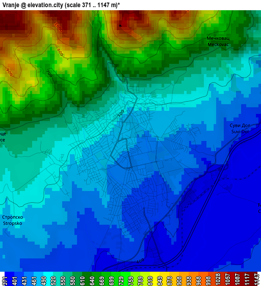
Below is the Elevation map of Vranje, which displays elevation range with different colors. Scale of the first map is from 371 to 1147 m (1217 to 3763 ft) with average elevation of 548.2 meters (=1799 ft) [note 1]
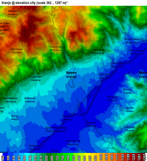
These maps also provides idea of topography and contour of this city, they are displayed at different zoom levels. More info about maps, scale and edge coordinates you can find below images.
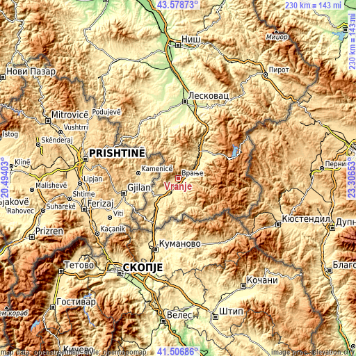
| \ | Map #1 | Map #2 | Topo.Map |
| Scale [m] | 371..1147 m | 362..1297 m | × |
| Scale [ft] | 1217..3763 ft | 1188..4255 ft | × |
| Average | 548.2 m = 1799 ft | 631.3 m = 2071 ft | × |
| Width | 7.2 km = 4.5 mi | 14.4 km = 8.9 mi | 230.4 km = 143.2 mi |
| Height | 7.2 km = 4.5 mi | 14.4 km = 8.9 mi | 230.4 km = 143.2 mi |
| ↑Max Latitude | 42.583755° | 42.616103° | 43.57873° |
| Latitude at center | 42.55139° | 42.55139° | 42.55139° |
| ↓Min Latitude | 42.519008° | 42.48661° | 41.50686° |
| ← Min Longitude | 21.856335° | 21.812389° | 20.49403° |
| Longitude center | 21.90028° | 21.90028° | 21.90028° |
| →Max Longitude | 21.944225° | 21.988171° | 23.30653° |
Nearby cities:
Cities around Vranje sort by population:
• Samoljica elevation 443 m
22.9 km,  215°
215°
• Sumulicë 440 m
22.8 km, 216°
• Biljača 461 m
25.1 km,  209°
209°
• Rajince 447 m
25.5 km, 221°
• Žujince 444 m
30.8 km, 211°
• Lagja e Poshtme 449 m
22.9 km, 217°
• Radovnica 1282 m
29.9 km,  115°
115°
• Surdulica 483 m
27 km,  55°
55°
• Trgovište 623 m
25.6 km,  144°
144°
• Vladičin Han 331 m
21.9 km,  37°
37°
• Bujanovac 401 m
15 km,  226°
226°
• Vranjska Banja 395 m
7.5 km,  86°
86°
Multilingual:
 En español:
Vranje elevación 468 m.
 En France:
Vranje élévation 468 m.


Sources and notes:
- [note 1] Map square and city borders are not equal. Map elevation data is calculated only from area inside that square.
- [src 1] Elevation data from geonames database provided with same terms of usage.
- [src 2] The elevation map of Vranje is generated using elevation data from NASA's 3 arcsec (90m) resolution SRTM data.
- [src 3] Base (background) map © OpenStreetMap contributors tiles are generated by Geofabrik and OpenTopoMap.
Copyright & License:
This Vranje Elevation Map is licensed under CC BY-SA. You may reuse any part from this page, if you give a proper credit by linking to this URL:
 More info on terms of use page.