Agigea elevation
Agigea (Constanța, Comuna Agigea), Romania elevation is 2 meters and Agigea elevation in feet is 7 ft above sea level [src 1]. Agigea is a seat of a second-order administrative division (feature code) with elevation that is 250 meters (820 ft) smaller than average city elevation in Romania.
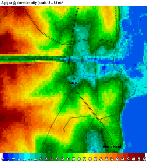
Below is the Elevation map of Agigea, which displays elevation range with different colors. Scale of the first map is from -8 to 63 m (-26 to 207 ft) with average elevation of 25.2 meters (=83 ft) [note 1]
These maps also provides idea of topography and contour of this city, they are displayed at different zoom levels. More info about maps, scale and edge coordinates you can find below images.
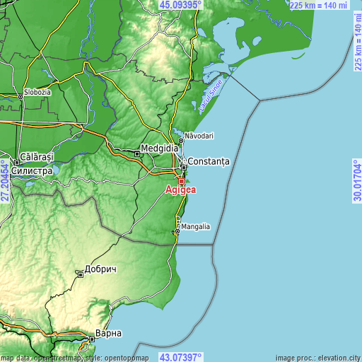
| \ | Map #1 | Map #2 | Topo.Map |
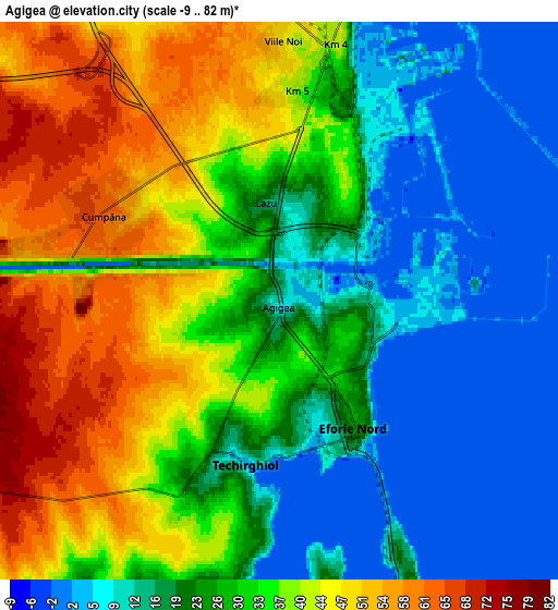
| Scale [m] | -8..63 m | -9..82 m | × |
| Scale [ft] | -26..207 ft | -30..269 ft | × |
| Average | 25.2 m = 83 ft | 28.4 m = 93 ft | × |
| Width | 7.02 km = 4.4 mi | 14.04 km = 8.7 mi | 224.6 km = 139.6 mi |
| Height | 7.02 km = 4.4 mi | 14.04 km = 8.7 mi | 224.6 km = 139.6 mi |
| ↑Max Latitude | 44.124134° | 44.155671° | 45.09395° |
| Latitude at center | 44.09258° | 44.09258° | 44.09258° |
| ↓Min Latitude | 44.061009° | 44.029422° | 43.07397° |
| ← Min Longitude | 28.566845° | 28.522899° | 27.20454° |
| Longitude center | 28.61079° | 28.61079° | 28.61079° |
| →Max Longitude | 28.654735° | 28.698681° | 30.01704° |
Nearby cities:
Cities around Agigea sort by population:
• Constanţa elevation 40 m
10 km,  10°
10°
• Cumpăna 50 m
4.4 km,  307°
307°
• Eforie Sud 23 m
8.3 km,  158°
158°
• Valu lui Traian 36 m
14.1 km, 305°
• Techirghiol 18 m
4.8 km,  190°
190°
• Tuzla 15 m
10.5 km,  170°
170°
• Topraisar 84 m
15.4 km,  236°
236°
• Eforie Nord 23 m
3.5 km,  150°
150°
• Palazu Mare 17 m
15.2 km,  357°
357°
• Costineşti 7 m
16 km, 173°
• Bărăganu 85 m
15.3 km,  268°
268°
• Eforie 13 m
6.5 km, 153°
Multilingual:
 En español:
Agigea elevación 2 m.
 En France:
Agigea élévation 2 m.


Sources and notes:
- [note 1] Map square and city borders are not equal. Map elevation data is calculated only from area inside that square.
- [src 1] Elevation data from geonames database provided with same terms of usage.
- [src 2] The elevation map of Agigea is generated using elevation data from NASA's 3 arcsec (90m) resolution SRTM data.
- [src 3] Base (background) map © OpenStreetMap contributors tiles are generated by Geofabrik and OpenTopoMap.
Copyright & License:
This Agigea Elevation Map is licensed under CC BY-SA. You may reuse any part from this page, if you give a proper credit by linking to this URL:
 More info on terms of use page.