Bărăganu elevation
Bărăganu (Constanța, Comuna Bărăganu), Romania elevation is 85 meters and Bărăganu elevation in feet is 279 ft above sea level [src 1]. Bărăganu is a seat of a second-order administrative division (feature code) with elevation that is 167 meters (548 ft) smaller than average city elevation in Romania.
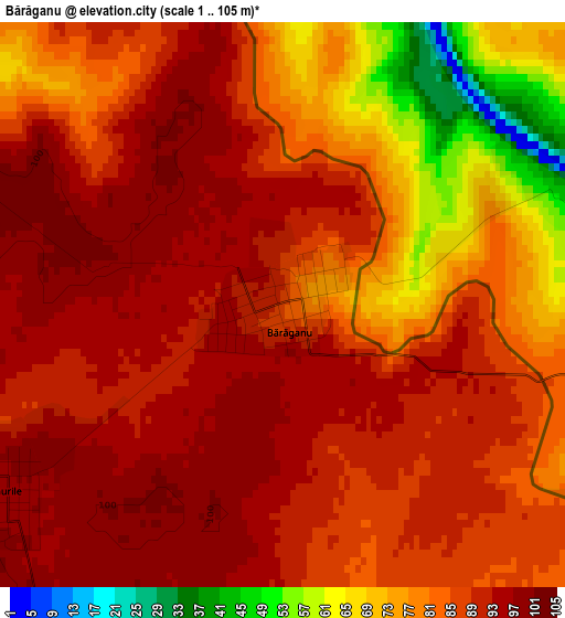
Below is the Elevation map of Bărăganu, which displays elevation range with different colors. Scale of the first map is from 1 to 105 m (3 to 344 ft) with average elevation of 85.1 meters (=279 ft) [note 1]
These maps also provides idea of topography and contour of this city, they are displayed at different zoom levels. More info about maps, scale and edge coordinates you can find below images.
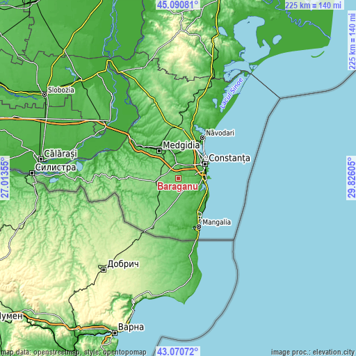
| \ | Map #1 | Topo.Map |
| Scale [m] | 1..105 m | × |
| Scale [ft] | 3..344 ft | × |
| Average | 85.1 m = 279 ft | × |
| Width | 7.02 km = 4.4 mi | 224.6 km = 139.6 mi |
| Height | 7.02 km = 4.4 mi | 224.6 km = 139.6 mi |
| ↑Max Latitude | 44.120946° | 45.09081° |
| Latitude at center | 44.08939° | 44.08939° |
| ↓Min Latitude | 44.057818° | 43.07072° |
| ← Min Longitude | 28.375855° | 27.01355° |
| Longitude center | 28.4198° | 28.4198° |
| →Max Longitude | 28.463745° | 29.82605° |
Nearby cities:
Cities around Bărăganu sort by population:
• Murfatlar elevation 41 m
10.4 km,  358°
358°
• Cumpăna 50 m
12.1 km,  75°
75°
• Valu lui Traian 36 m
9.4 km,  23°
23°
• Techirghiol 18 m
15 km,  106°
106°
• Agigea 2 m
15.3 km,  88°
88°
• Topraisar 84 m
8.4 km,  163°
163°
• Poarta Albă 18 m
14.2 km,  353°
353°
• Mereni 99 m
6.1 km,  224°
224°
• Ciocârlia 130 m
11 km,  276°
276°
• Ciocârlia de Sus 106 m
7.5 km,  294°
294°
• Valea Dacilor 105 m
14.3 km,  325°
325°
• Siminoc 84 m
10.3 km, 328°
Multilingual:
 En español:
Bărăganu elevación 85 m.
 En France:
Bărăganu élévation 85 m.


Sources and notes:
- [note 1] Map square and city borders are not equal. Map elevation data is calculated only from area inside that square.
- [src 1] Elevation data from geonames database provided with same terms of usage.
- [src 2] The elevation map of Bărăganu is generated using elevation data from NASA's 3 arcsec (90m) resolution SRTM data.
- [src 3] Base (background) map © OpenStreetMap contributors tiles are generated by Geofabrik and OpenTopoMap.
Copyright & License:
This Bărăganu Elevation Map is licensed under CC BY-SA. You may reuse any part from this page, if you give a proper credit by linking to this URL:
 More info on terms of use page.