Andrieşeni elevation
Andrieşeni (Iaşi, Comuna Andrieşeni), Romania elevation is 60 meters and Andrieşeni elevation in feet is 197 ft above sea level [src 1]. Andrieşeni is a seat of a second-order administrative division (feature code) with elevation that is 192 meters (630 ft) smaller than average city elevation in Romania.
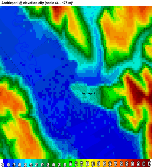
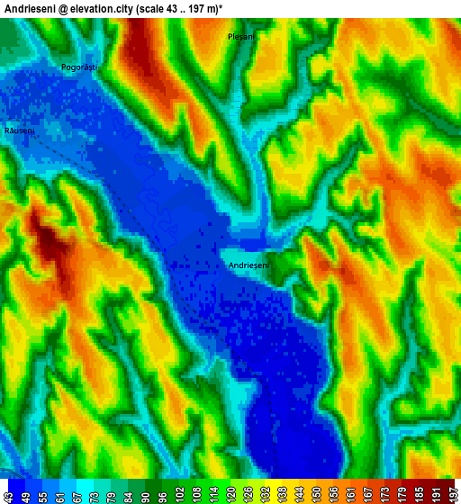
Below is the Elevation map of Andrieşeni, which displays elevation range with different colors. Scale of the first map is from 44 to 175 m (144 to 574 ft) with average elevation of 81.8 meters (=268 ft) [note 1]
These maps also provides idea of topography and contour of this city, they are displayed at different zoom levels. More info about maps, scale and edge coordinates you can find below images.
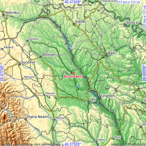
| \ | Map #1 | Map #2 | Topo.Map |
| Scale [m] | 44..175 m | 43..197 m | × |
| Scale [ft] | 144..574 ft | 141..646 ft | × |
| Average | 81.8 m = 268 ft | 103.4 m = 339 ft | × |
| Width | 6.6 km = 4.1 mi | 13.2 km = 8.2 mi | 211.1 km = 131.2 mi |
| Height | 6.6 km = 4.1 mi | 13.2 km = 8.2 mi | 211.1 km = 131.2 mi |
| ↑Max Latitude | 47.562992° | 47.592637° | 48.47419° |
| Latitude at center | 47.53333° | 47.53333° | 47.53333° |
| ↓Min Latitude | 47.503651° | 47.473956° | 46.57528° |
| ← Min Longitude | 27.239385° | 27.195439° | 25.87708° |
| Longitude center | 27.28333° | 27.28333° | 27.28333° |
| →Max Longitude | 27.327275° | 27.371221° | 28.68958° |
Nearby cities:
Cities around Andrieşeni sort by population:
• Şipote elevation 54 m
8.9 km,  214°
214°
• Bivolari 62 m
11.3 km,  90°
90°
• Vlădeni 49 m
13.5 km,  163°
163°
• Călăraşi 176 m
9.4 km,  352°
352°
• Hlipiceni 56 m
12.5 km,  306°
306°
• Răuseni 53 m
7.3 km,  300°
300°
• Chișcăreni 60 m
9.6 km,  222°
222°
• Victoria 100 m
12.2 km, 314°
• Iazu Nou 62 m
7.9 km, 224°
• Santa Mare 102 m
10.5 km,  28°
28°
• Tabăra 65 m
10.7 km,  64°
64°
• Roșcani 97 m
12.3 km,  134°
134°
Multilingual:
 En español:
Andrieşeni elevación 60 m.
 En France:
Andrieşeni élévation 60 m.
 Auf Deutsch:
Andrieşeni höhe über dem Meeresspiegel ist 60 m.

Sources and notes:
- [note 1] Map square and city borders are not equal. Map elevation data is calculated only from area inside that square.
- [src 1] Elevation data from geonames database provided with same terms of usage.
- [src 2] The elevation map of Andrieşeni is generated using elevation data from NASA's 3 arcsec (90m) resolution SRTM data.
- [src 3] Base (background) map © OpenStreetMap contributors tiles are generated by Geofabrik and OpenTopoMap.
Copyright & License:
This Andrieşeni Elevation Map is licensed under CC BY-SA. You may reuse any part from this page, if you give a proper credit by linking to this URL:
 More info on terms of use page.