Şipote elevation
Şipote (Iaşi, Comuna Şipote), Romania elevation is 54 meters and Şipote elevation in feet is 177 ft above sea level [src 1]. Şipote is a seat of a second-order administrative division (feature code) with elevation that is 198 meters (650 ft) smaller than average city elevation in Romania.
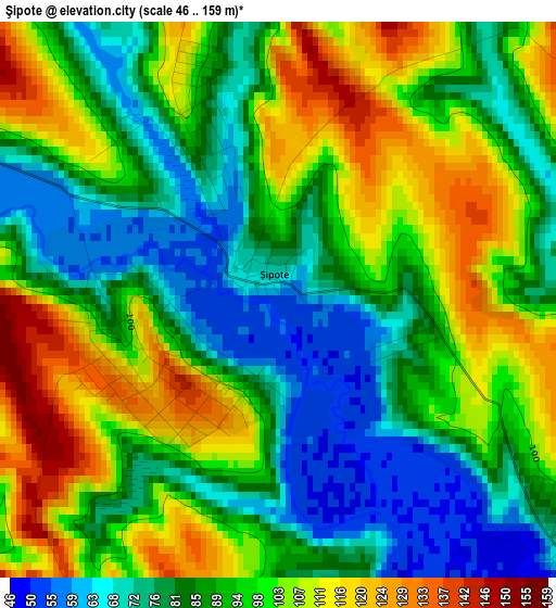
Below is the Elevation map of Şipote, which displays elevation range with different colors. Scale of the first map is from 46 to 159 m (151 to 522 ft) with average elevation of 92.8 meters (=304 ft) [note 1]
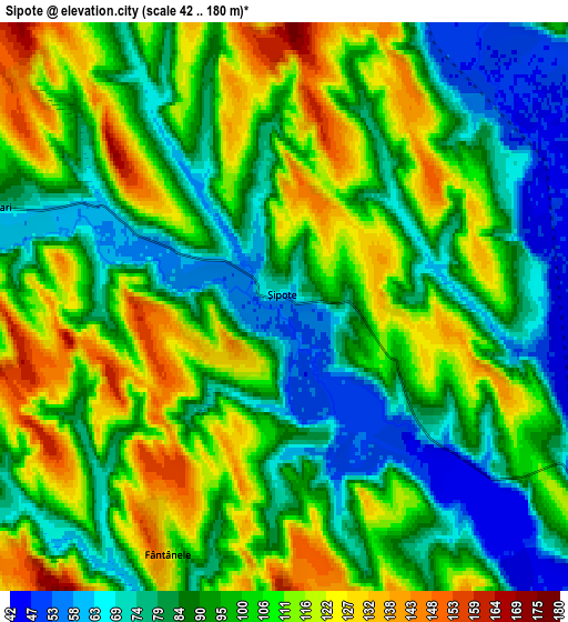
These maps also provides idea of topography and contour of this city, they are displayed at different zoom levels. More info about maps, scale and edge coordinates you can find below images.
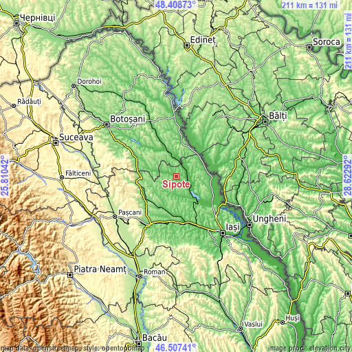
| \ | Map #1 | Map #2 | Topo.Map |
| Scale [m] | 46..159 m | 42..180 m | × |
| Scale [ft] | 151..522 ft | 138..591 ft | × |
| Average | 92.8 m = 304 ft | 97.6 m = 320 ft | × |
| Width | 6.61 km = 4.1 mi | 13.21 km = 8.2 mi | 211.4 km = 131.4 mi |
| Height | 6.61 km = 4.1 mi | 13.21 km = 8.2 mi | 211.4 km = 131.4 mi |
| ↑Max Latitude | 47.496369° | 47.526052° | 48.40873° |
| Latitude at center | 47.46667° | 47.46667° | 47.46667° |
| ↓Min Latitude | 47.436954° | 47.407221° | 46.50741° |
| ← Min Longitude | 27.172725° | 27.128779° | 25.81042° |
| Longitude center | 27.21667° | 27.21667° | 27.21667° |
| →Max Longitude | 27.260615° | 27.304561° | 28.62292° |
Nearby cities:
Cities around Şipote sort by population:
• Focuri elevation 98 m
13 km,  180°
180°
• Andrieşeni 60 m
8.9 km,  34°
34°
• Vlădeni 49 m
10.4 km,  122°
122°
• Plugari 62 m
9 km,  281°
281°
• Gropniţa 104 m
13.2 km,  169°
169°
• Coarnele Caprei 103 m
12.8 km,  223°
223°
• Răuseni 53 m
11.2 km,  353°
353°
• Fântânele 124 m
6.4 km,  205°
205°
• Chișcăreni 60 m
1.6 km, 282°
• Borosoaia 139 m
8.9 km,  267°
267°
• Iazu Nou 62 m
1.9 km,  342°
342°
• Roșcani 97 m
13.9 km,  95°
95°
Multilingual:
 En español:
Şipote elevación 54 m.
 En France:
Şipote élévation 54 m.


Sources and notes:
- [note 1] Map square and city borders are not equal. Map elevation data is calculated only from area inside that square.
- [src 1] Elevation data from geonames database provided with same terms of usage.
- [src 2] The elevation map of Şipote is generated using elevation data from NASA's 3 arcsec (90m) resolution SRTM data.
- [src 3] Base (background) map © OpenStreetMap contributors tiles are generated by Geofabrik and OpenTopoMap.
Copyright & License:
This Şipote Elevation Map is licensed under CC BY-SA. You may reuse any part from this page, if you give a proper credit by linking to this URL:
 More info on terms of use page.