Apahida elevation
Apahida (Cluj, Comuna Apahida), Romania elevation is 299 meters and Apahida elevation in feet is 981 ft above sea level [src 1]. Apahida is a seat of a second-order administrative division (feature code) with elevation that is 47 meters (154 ft) bigger than average city elevation in Romania.
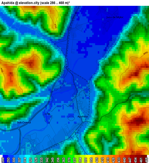
Below is the Elevation map of Apahida, which displays elevation range with different colors. Scale of the first map is from 286 to 468 m (938 to 1535 ft) with average elevation of 340 meters (=1115 ft) [note 1]
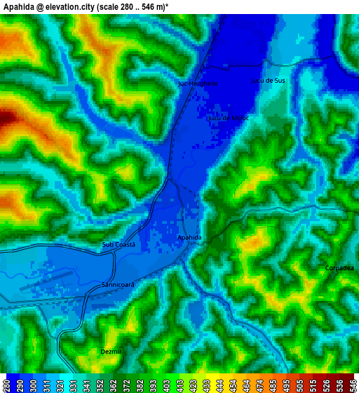
These maps also provides idea of topography and contour of this city, they are displayed at different zoom levels. More info about maps, scale and edge coordinates you can find below images.
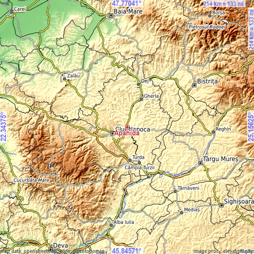
| \ | Map #1 | Map #2 | Topo.Map |
| Scale [m] | 286..468 m | 280..546 m | × |
| Scale [ft] | 938..1535 ft | 919..1791 ft | × |
| Average | 340 m = 1115 ft | 353.1 m = 1158 ft | × |
| Width | 6.69 km = 4.2 mi | 13.38 km = 8.3 mi | 214 km = 133 mi |
| Height | 6.69 km = 4.2 mi | 13.38 km = 8.3 mi | 214 km = 133 mi |
| ↑Max Latitude | 46.846735° | 46.876783° | 47.77041° |
| Latitude at center | 46.81667° | 46.81667° | 46.81667° |
| ↓Min Latitude | 46.786588° | 46.75649° | 45.84571° |
| ← Min Longitude | 23.706055° | 23.662109° | 22.34375° |
| Longitude center | 23.75° | 23.75° | 23.75° |
| →Max Longitude | 23.793945° | 23.837891° | 25.15625° |
Nearby cities:
Cities around Apahida sort by population:
• Cluj-Napoca elevation 352 m
12.7 km,  244°
244°
• Cojocna 326 m
9.8 km,  139°
139°
• Bonțida 276 m
12 km,  24°
24°
• Căianu Mic 357 m
13.2 km,  106°
106°
• Borşa 336 m
14.4 km,  333°
333°
• Răscruci 290 m
10 km,  8°
8°
• Aiton 628 m
14.9 km,  184°
184°
• Sânnicoară 307 m
3.5 km,  211°
211°
• Gheorghieni 556 m
12.3 km,  202°
202°
• Dezmir 353 m
6.1 km, 198°
• Vaida-Cămăraș 357 m
15.1 km,  85°
85°
• Căianu 339 m
13.3 km, 105°
Multilingual:
 En español:
Apahida elevación 299 m.
 En France:
Apahida élévation 299 m.


Sources and notes:
- [note 1] Map square and city borders are not equal. Map elevation data is calculated only from area inside that square.
- [src 1] Elevation data from geonames database provided with same terms of usage.
- [src 2] The elevation map of Apahida is generated using elevation data from NASA's 3 arcsec (90m) resolution SRTM data.
- [src 3] Base (background) map © OpenStreetMap contributors tiles are generated by Geofabrik and OpenTopoMap.
Copyright & License:
This Apahida Elevation Map is licensed under CC BY-SA. You may reuse any part from this page, if you give a proper credit by linking to this URL:
 More info on terms of use page.