Dezmir elevation
Dezmir (Cluj, Comuna Apahida), Romania elevation is 353 meters and Dezmir elevation in feet is 1158 ft above sea level [src 1]. Dezmir is a populated place (feature code) with elevation that is 101 meters (331 ft) bigger than average city elevation in Romania.
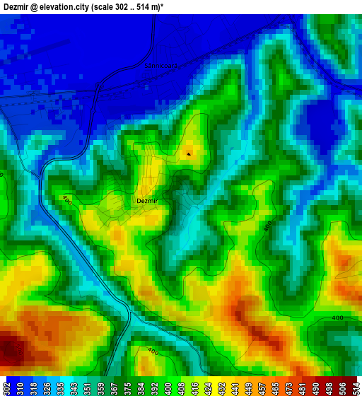
Below is the Elevation map of Dezmir, which displays elevation range with different colors. Scale of the first map is from 302 to 514 m (991 to 1686 ft) with average elevation of 369.1 meters (=1211 ft) [note 1]
These maps also provides idea of topography and contour of this city, they are displayed at different zoom levels. More info about maps, scale and edge coordinates you can find below images.
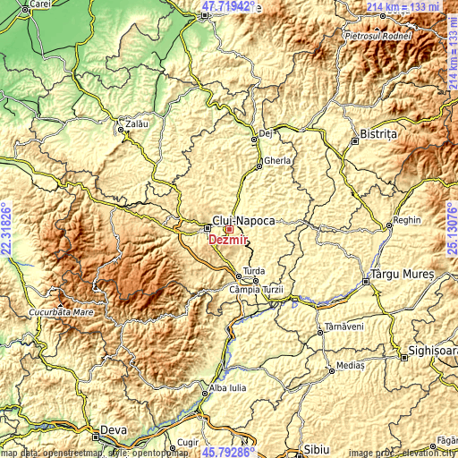
| \ | Map #1 | Topo.Map |
| Scale [m] | 302..514 m | × |
| Scale [ft] | 991..1686 ft | × |
| Average | 369.1 m = 1211 ft | × |
| Width | 6.69 km = 4.2 mi | 214.2 km = 133.1 mi |
| Height | 6.69 km = 4.2 mi | 214.2 km = 133.1 mi |
| ↑Max Latitude | 46.794844° | 47.71942° |
| Latitude at center | 46.76475° | 46.76475° |
| ↓Min Latitude | 46.734639° | 45.79286° |
| ← Min Longitude | 23.680565° | 22.31826° |
| Longitude center | 23.72451° | 23.72451° |
| →Max Longitude | 23.768455° | 25.13076° |
Nearby cities:
Cities around Dezmir sort by population:
• Cluj-Napoca elevation 352 m
9.5 km,  271°
271°
• Apahida 299 m
6.1 km,  18°
18°
• Baciu 395 m
16.3 km,  283°
283°
• Cojocna 326 m
8.5 km,  101°
101°
• Feleacu 690 m
9.8 km,  236°
236°
• Tureni 521 m
15.2 km,  186°
186°
• Căianu Mic 357 m
14.8 km,  81°
81°
• Răscruci 290 m
16 km,  12°
12°
• Aiton 628 m
9.1 km,  175°
175°
• Sânnicoară 307 m
2.8 km,  1°
1°
• Gheorghieni 556 m
6.3 km,  205°
205°
• Căianu 339 m
14.9 km, 81°
Multilingual:
 En español:
Dezmir elevación 353 m.
 En France:
Dezmir élévation 353 m.


Sources and notes:
- [note 1] Map square and city borders are not equal. Map elevation data is calculated only from area inside that square.
- [src 1] Elevation data from geonames database provided with same terms of usage.
- [src 2] The elevation map of Dezmir is generated using elevation data from NASA's 3 arcsec (90m) resolution SRTM data.
- [src 3] Base (background) map © OpenStreetMap contributors tiles are generated by Geofabrik and OpenTopoMap.
Copyright & License:
This Dezmir Elevation Map is licensed under CC BY-SA. You may reuse any part from this page, if you give a proper credit by linking to this URL:
 More info on terms of use page.