Băbeni elevation
Băbeni (Vâlcea, Oraş Bãbeni), Romania elevation is 205 meters and Băbeni elevation in feet is 673 ft above sea level [src 1]. Băbeni is a seat of a second-order administrative division (feature code) with elevation that is 47 meters (154 ft) smaller than average city elevation in Romania.
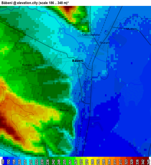
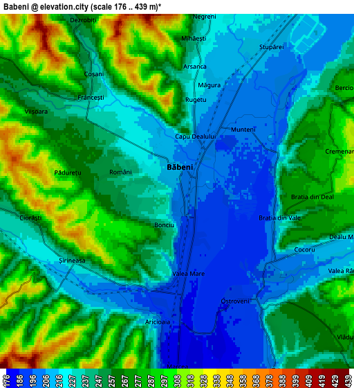
Below is the Elevation map of Băbeni, which displays elevation range with different colors. Scale of the first map is from 186 to 348 m (610 to 1142 ft) with average elevation of 222.9 meters (=731 ft) [note 1]
These maps also provides idea of topography and contour of this city, they are displayed at different zoom levels. More info about maps, scale and edge coordinates you can find below images.
| \ | Map #1 | Map #2 | Topo.Map |
| Scale [m] | 186..348 m | 176..439 m | × |
| Scale [ft] | 610..1142 ft | 577..1440 ft | × |
| Average | 222.9 m = 731 ft | 249 m = 817 ft | × |
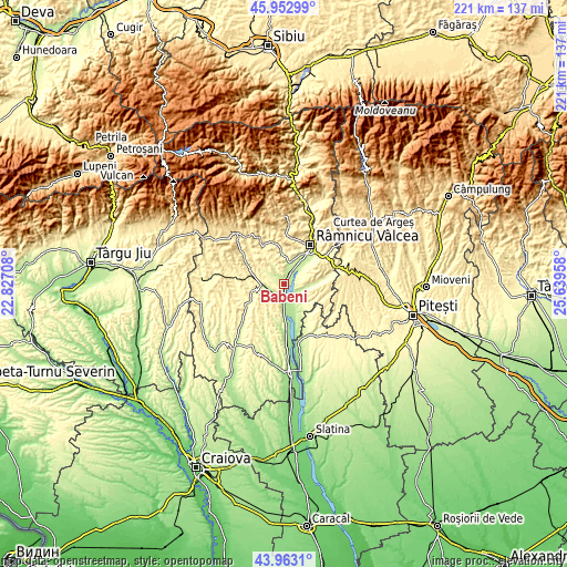
| Width | 6.91 km = 4.3 mi | 13.83 km = 8.6 mi | 221.3 km = 137.5 mi |
| Height | 6.91 km = 4.3 mi | 13.83 km = 8.6 mi | 221.2 km = 137.4 mi |
| ↑Max Latitude | 44.997754° | 45.02882° | 45.95299° |
| Latitude at center | 44.96667° | 44.96667° | 44.96667° |
| ↓Min Latitude | 44.935569° | 44.904452° | 43.9631° |
| ← Min Longitude | 24.189385° | 24.145439° | 22.82708° |
| Longitude center | 24.23333° | 24.23333° | 24.23333° |
| →Max Longitude | 24.277275° | 24.321221° | 25.63958° |
Nearby cities:
Cities around Băbeni sort by population:
• Mihăeşti elevation 234 m
7.5 km,  10°
10°
• Galicea 253 m
6.8 km,  144°
144°
• Popeşti 263 m
10.6 km,  280°
280°
• Dăeşti 273 m
7.9 km,  270°
270°
• Şirineasa 201 m
4.5 km,  215°
215°
• Valea Mare 190 m
3.2 km,  172°
172°
• Pesceana 319 m
11.4 km, 215°
• Stolniceni 217 m
9.9 km,  35°
35°
• Coșani 240 m
5.6 km,  324°
324°
• Români 245 m
2.3 km,  287°
287°
• Urși 283 m
11.8 km, 285°
• Mănăilești 282 m
10.7 km,  306°
306°
Multilingual:
 En español:
Băbeni elevación 205 m.
 En France:
Băbeni élévation 205 m.


Sources and notes:
- [note 1] Map square and city borders are not equal. Map elevation data is calculated only from area inside that square.
- [src 1] Elevation data from geonames database provided with same terms of usage.
- [src 2] The elevation map of Băbeni is generated using elevation data from NASA's 3 arcsec (90m) resolution SRTM data.
- [src 3] Base (background) map © OpenStreetMap contributors tiles are generated by Geofabrik and OpenTopoMap.
Copyright & License:
This Băbeni Elevation Map is licensed under CC BY-SA. You may reuse any part from this page, if you give a proper credit by linking to this URL:
 More info on terms of use page.