Coșani elevation
Coșani (Vâlcea, Comuna Frânceşti-Mânăstireni), Romania elevation is 240 meters and Coșani elevation in feet is 787 ft above sea level [src 1]. Coșani is a populated place (feature code) with elevation that is 12 meters (39 ft) smaller than average city elevation in Romania.
Below is the Elevation map of Coșani, which displays elevation range with different colors. Scale of the first map is from 204 to 464 m (669 to 1522 ft) with average elevation of 294.1 meters (=965 ft) [note 1]
These maps also provides idea of topography and contour of this city, they are displayed at different zoom levels. More info about maps, scale and edge coordinates you can find below images.
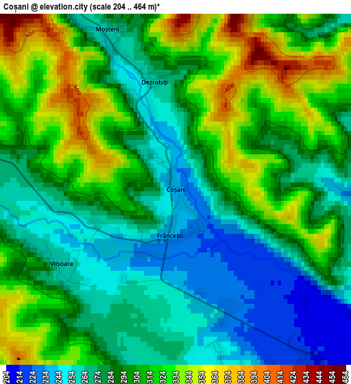
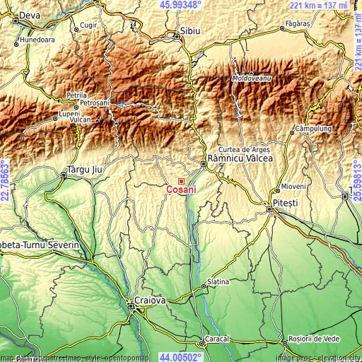
| \ | Map #1 | Topo.Map |
| Scale [m] | 204..464 m | × |
| Scale [ft] | 669..1522 ft | × |
| Average | 294.1 m = 965 ft | × |
| Width | 6.91 km = 4.3 mi | 221.1 km = 137.4 mi |
| Height | 6.91 km = 4.3 mi | 221.1 km = 137.4 mi |
| ↑Max Latitude | 45.038941° | 45.99348° |
| Latitude at center | 45.00788° | 45.00788° |
| ↓Min Latitude | 44.976802° | 44.00502° |
| ← Min Longitude | 24.147935° | 22.78563° |
| Longitude center | 24.19188° | 24.19188° |
| →Max Longitude | 24.235825° | 25.59813° |
Nearby cities:
Cities around Coșani sort by population:
• Băbeni elevation 205 m
5.6 km,  144°
144°
• Mihăeşti 234 m
5.4 km,  58°
58°
• Popeşti 263 m
7.7 km,  249°
249°
• Băile Govora 363 m
8.4 km,  355°
355°
• Dăeşti 273 m
6.5 km,  225°
225°
• Şirineasa 201 m
8.3 km,  175°
175°
• Prajila 387 m
8.5 km,  348°
348°
• Valea Mare 190 m
8.6 km,  154°
154°
• Români 245 m
4 km,  164°
164°
• Urși 283 m
8.2 km,  259°
259°
• Mănăilești 282 m
5.6 km,  289°
289°
• Păuşeşti 305 m
8.6 km,  328°
328°
Multilingual:
 En español:
Coșani elevación 240 m.
 En France:
Coșani élévation 240 m.


Sources and notes:
- [note 1] Map square and city borders are not equal. Map elevation data is calculated only from area inside that square.
- [src 1] Elevation data from geonames database provided with same terms of usage.
- [src 2] The elevation map of Coșani is generated using elevation data from NASA's 3 arcsec (90m) resolution SRTM data.
- [src 3] Base (background) map © OpenStreetMap contributors tiles are generated by Geofabrik and OpenTopoMap.
Copyright & License:
This Coșani Elevation Map is licensed under CC BY-SA. You may reuse any part from this page, if you give a proper credit by linking to this URL:
 More info on terms of use page.