Băileşti elevation
Băileşti (Dolj, Municipiul Bãileşti), Romania elevation is 55 meters and Băileşti elevation in feet is 180 ft above sea level [src 1]. Băileşti is a seat of a second-order administrative division (feature code) with elevation that is 197 meters (646 ft) smaller than average city elevation in Romania.
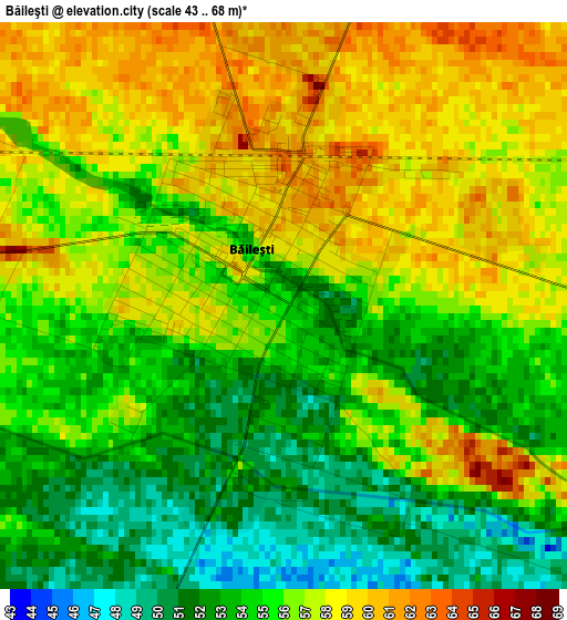
Below is the Elevation map of Băileşti, which displays elevation range with different colors. Scale of the first map is from 43 to 68 m (141 to 223 ft) with average elevation of 55.4 meters (=182 ft) [note 1]
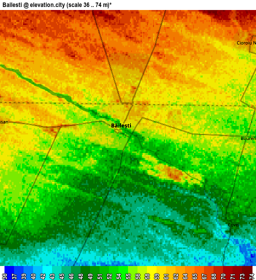
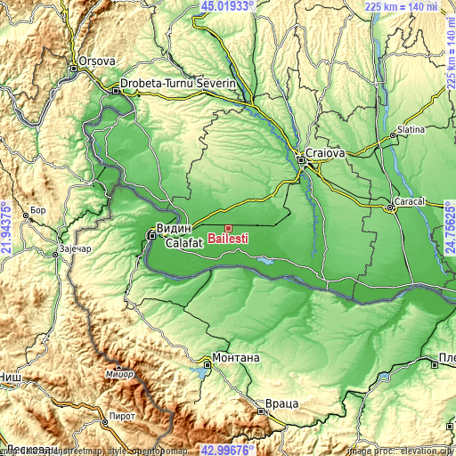
These maps also provides idea of topography and contour of this city, they are displayed at different zoom levels. More info about maps, scale and edge coordinates you can find below images.
| \ | Map #1 | Map #2 | Topo.Map |
| Scale [m] | 43..68 m | 36..74 m | × |
| Scale [ft] | 141..223 ft | 118..243 ft | × |
| Average | 55.4 m = 182 ft | 55.7 m = 183 ft | × |
| Width | 7.03 km = 4.4 mi | 14.06 km = 8.7 mi | 224.9 km = 139.7 mi |
| Height | 7.03 km = 4.4 mi | 14.06 km = 8.7 mi | 224.9 km = 139.7 mi |
| ↑Max Latitude | 44.048264° | 44.079842° | 45.01933° |
| Latitude at center | 44.01667° | 44.01667° | 44.01667° |
| ↓Min Latitude | 43.985059° | 43.953431° | 42.99676° |
| ← Min Longitude | 23.306055° | 23.262109° | 21.94375° |
| Longitude center | 23.35° | 23.35° | 23.35° |
| →Max Longitude | 23.393945° | 23.437891° | 24.75625° |
Nearby cities:
Cities around Băileşti sort by population:
• Moţăţei elevation 69 m
14.1 km,  301°
301°
• Galicea Mare 76 m
10.1 km,  336°
336°
• Giubega 117 m
13.1 km,  20°
20°
• Afumaţi 52 m
9.5 km,  101°
101°
• Negoi 36 m
11.6 km,  170°
170°
• Seaca de Câmp 41 m
14.1 km,  229°
229°
• Izvoare 130 m
15.2 km, 343°
• Siliştea Crucii 52 m
10.8 km,  80°
80°
• Boureni 56 m
6.7 km,  90°
90°
• Cioroiași 72 m
10.9 km,  47°
47°
• Catane 38 m
11.2 km,  153°
153°
• Galiciuica 93 m
10.2 km, 18°
Multilingual:
 En español:
Băileşti elevación 55 m.
 En France:
Băileşti élévation 55 m.


Sources and notes:
- [note 1] Map square and city borders are not equal. Map elevation data is calculated only from area inside that square.
- [src 1] Elevation data from geonames database provided with same terms of usage.
- [src 2] The elevation map of Băileşti is generated using elevation data from NASA's 3 arcsec (90m) resolution SRTM data.
- [src 3] Base (background) map © OpenStreetMap contributors tiles are generated by Geofabrik and OpenTopoMap.
Copyright & License:
This Băileşti Elevation Map is licensed under CC BY-SA. You may reuse any part from this page, if you give a proper credit by linking to this URL:
 More info on terms of use page.