Băișești elevation
Băișești (Suceava, Comuna Cornu Luncii), Romania elevation is 398 meters and Băișești elevation in feet is 1306 ft above sea level [src 1]. Băișești is a populated place (feature code) with elevation that is 146 meters (479 ft) bigger than average city elevation in Romania.
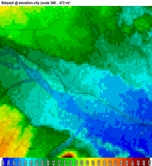
Below is the Elevation map of Băișești, which displays elevation range with different colors. Scale of the first map is from 380 to 472 m (1247 to 1549 ft) with average elevation of 405.8 meters (=1331 ft) [note 1]
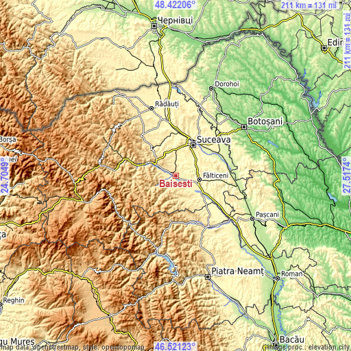
These maps also provides idea of topography and contour of this city, they are displayed at different zoom levels. More info about maps, scale and edge coordinates you can find below images.
| \ | Map #1 | Topo.Map |
| Scale [m] | 380..472 m | × |
| Scale [ft] | 1247..1549 ft | × |
| Average | 405.8 m = 1331 ft | × |
| Width | 6.6 km = 4.1 mi | 211.4 km = 131.4 mi |
| Height | 6.6 km = 4.1 mi | 211.3 km = 131.3 mi |
| ↑Max Latitude | 47.509932° | 48.42206° |
| Latitude at center | 47.48024° | 47.48024° |
| ↓Min Latitude | 47.450531° | 46.52123° |
| ← Min Longitude | 26.067205° | 24.7049° |
| Longitude center | 26.11115° | 26.11115° |
| →Max Longitude | 26.155095° | 27.5174° |
Nearby cities:
Cities around Băișești sort by population:
• Cornu Luncii elevation 385 m
3.3 km,  117°
117°
• Mălini 403 m
2.6 km,  234°
234°
• Valea Moldovei 487 m
6 km,  255°
255°
• Slatina 454 m
7.9 km,  244°
244°
• Horodniceni 384 m
7.2 km,  35°
35°
• Berchișești 463 m
7.6 km,  308°
308°
• Pâraie 438 m
3.9 km, 240°
• Drăgoiești 397 m
8 km,  344°
344°
• Mironu 440 m
7.7 km,  276°
276°
• Herla 476 m
8.5 km, 240°
• Brăiești 417 m
3.5 km,  301°
301°
• Măzănăești 454 m
5.7 km, 338°
Multilingual:
 En español:
Băișești elevación 398 m.
 En France:
Băișești élévation 398 m.
 Auf Deutsch:
Băișești höhe über dem Meeresspiegel ist 398 m.

Sources and notes:
- [note 1] Map square and city borders are not equal. Map elevation data is calculated only from area inside that square.
- [src 1] Elevation data from geonames database provided with same terms of usage.
- [src 2] The elevation map of Băișești is generated using elevation data from NASA's 3 arcsec (90m) resolution SRTM data.
- [src 3] Base (background) map © OpenStreetMap contributors tiles are generated by Geofabrik and OpenTopoMap.
Copyright & License:
This Băișești Elevation Map is licensed under CC BY-SA. You may reuse any part from this page, if you give a proper credit by linking to this URL:
 More info on terms of use page.