Mironu elevation
Mironu (Suceava, Comuna Valea Moldovei), Romania elevation is 440 meters and Mironu elevation in feet is 1444 ft above sea level [src 1]. Mironu is a populated place (feature code) with elevation that is 188 meters (617 ft) bigger than average city elevation in Romania.
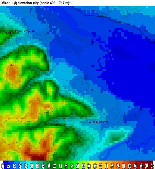
Below is the Elevation map of Mironu, which displays elevation range with different colors. Scale of the first map is from 409 to 717 m (1342 to 2352 ft) with average elevation of 475.5 meters (=1560 ft) [note 1]
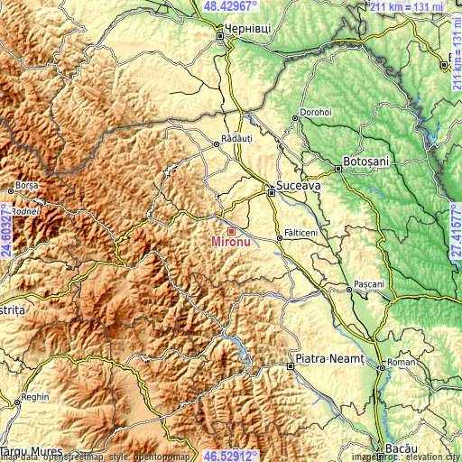
These maps also provides idea of topography and contour of this city, they are displayed at different zoom levels. More info about maps, scale and edge coordinates you can find below images.
| \ | Map #1 | Topo.Map |
| Scale [m] | 409..717 m | × |
| Scale [ft] | 1342..2352 ft | × |
| Average | 475.5 m = 1560 ft | × |
| Width | 6.6 km = 4.1 mi | 211.3 km = 131.3 mi |
| Height | 6.6 km = 4.1 mi | 211.3 km = 131.3 mi |
| ↑Max Latitude | 47.517677° | 48.42967° |
| Latitude at center | 47.48799° | 47.48799° |
| ↓Min Latitude | 47.458286° | 46.52912° |
| ← Min Longitude | 25.965575° | 24.60327° |
| Longitude center | 26.00952° | 26.00952° |
| →Max Longitude | 26.053465° | 27.41577° |
Nearby cities:
Cities around Mironu sort by population:
• Mălini elevation 403 m
6 km,  113°
113°
• Valea Moldovei 487 m
3 km,  142°
142°
• Păltinoasa 459 m
8.2 km,  327°
327°
• Slatina 454 m
4.3 km,  172°
172°
• Capu Codrului 456 m
5.1 km,  340°
340°
• Capu Câmpului 453 m
3.2 km,  315°
315°
• Berchișești 463 m
4.3 km,  23°
23°
• Pâraie 438 m
5.1 km,  123°
123°
• Băișești 398 m
7.7 km,  96°
96°
• Herla 476 m
5 km,  177°
177°
• Brăiești 417 m
4.8 km,  78°
78°
• Măzănăești 454 m
7.1 km,  51°
51°
Multilingual:
 En español:
Mironu elevación 440 m.
 En France:
Mironu élévation 440 m.


Sources and notes:
- [note 1] Map square and city borders are not equal. Map elevation data is calculated only from area inside that square.
- [src 1] Elevation data from geonames database provided with same terms of usage.
- [src 2] The elevation map of Mironu is generated using elevation data from NASA's 3 arcsec (90m) resolution SRTM data.
- [src 3] Base (background) map © OpenStreetMap contributors tiles are generated by Geofabrik and OpenTopoMap.
Copyright & License:
This Mironu Elevation Map is licensed under CC BY-SA. You may reuse any part from this page, if you give a proper credit by linking to this URL:
 More info on terms of use page.