Băiuţ elevation
Băiuţ (Maramureş, Comuna Băiuţ), Romania elevation is 626 meters and Băiuţ elevation in feet is 2054 ft above sea level [src 1]. Băiuţ is a seat of a second-order administrative division (feature code) with elevation that is 374 meters (1227 ft) bigger than average city elevation in Romania.
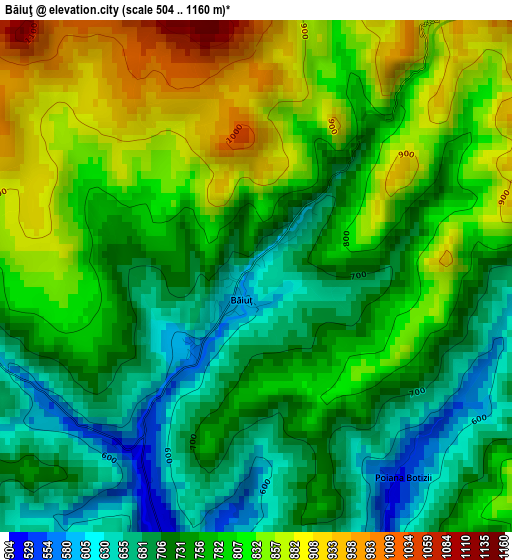
Below is the Elevation map of Băiuţ, which displays elevation range with different colors. Scale of the first map is from 504 to 1160 m (1654 to 3806 ft) with average elevation of 769.2 meters (=2524 ft) [note 1]
These maps also provides idea of topography and contour of this city, they are displayed at different zoom levels. More info about maps, scale and edge coordinates you can find below images.
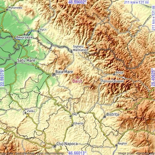
| \ | Map #1 | Topo.Map |
| Scale [m] | 504..1160 m | × |
| Scale [ft] | 1654..3806 ft | × |
| Average | 769.2 m = 2524 ft | × |
| Width | 6.59 km = 4.1 mi | 210.8 km = 131 mi |
| Height | 6.59 km = 4.1 mi | 210.8 km = 131 mi |
| ↑Max Latitude | 47.646285° | 48.55602° |
| Latitude at center | 47.61667° | 47.61667° |
| ↓Min Latitude | 47.587039° | 46.66013° |
| ← Min Longitude | 23.956055° | 22.59375° |
| Longitude center | 24° | 24° |
| →Max Longitude | 24.043945° | 25.40625° |
Nearby cities:
Cities around Băiuţ sort by population:
• Cavnic elevation 859 m
11.4 km,  299°
299°
• Lăpuş 390 m
13 km,  174°
174°
• Cupşeni 488 m
8.9 km,  214°
214°
• Budeşti 601 m
13.5 km,  343°
343°
• Botiza 483 m
12.5 km,  63°
63°
• Groșii Țibleșului 491 m
14.9 km,  161°
161°
• Ungureni 387 m
8.6 km,  204°
204°
• Rogoz 351 m
17.4 km, 197°
• Breb 501 m
16.3 km,  334°
334°
• Libotin 374 m
12.6 km,  190°
190°
• Sârbi 477 m
16.7 km,  345°
345°
• Poienile Izei 507 m
12.7 km,  43°
43°
Multilingual:
 En español:
Băiuţ elevación 626 m.
 En France:
Băiuţ élévation 626 m.


Sources and notes:
- [note 1] Map square and city borders are not equal. Map elevation data is calculated only from area inside that square.
- [src 1] Elevation data from geonames database provided with same terms of usage.
- [src 2] The elevation map of Băiuţ is generated using elevation data from NASA's 3 arcsec (90m) resolution SRTM data.
- [src 3] Base (background) map © OpenStreetMap contributors tiles are generated by Geofabrik and OpenTopoMap.
Copyright & License:
This Băiuţ Elevation Map is licensed under CC BY-SA. You may reuse any part from this page, if you give a proper credit by linking to this URL:
 More info on terms of use page.