Balintești elevation
Balintești (Galaţi, Comuna Bereşti-Meria), Romania elevation is 109 meters and Balintești elevation in feet is 358 ft above sea level [src 1]. Balintești is a populated place (feature code) with elevation that is 143 meters (469 ft) smaller than average city elevation in Romania.
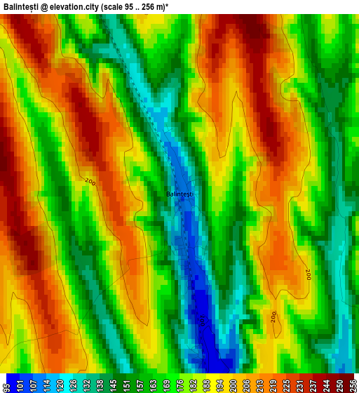
Below is the Elevation map of Balintești, which displays elevation range with different colors. Scale of the first map is from 95 to 256 m (312 to 840 ft) with average elevation of 179.5 meters (=589 ft) [note 1]
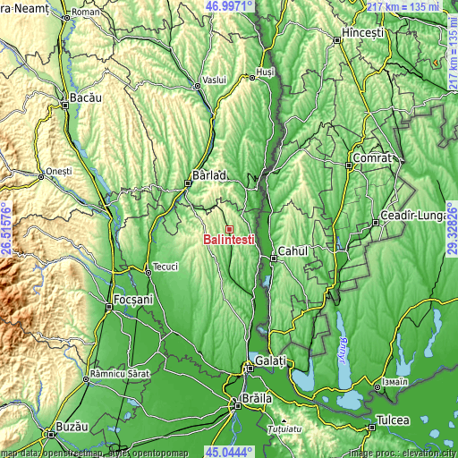
These maps also provides idea of topography and contour of this city, they are displayed at different zoom levels. More info about maps, scale and edge coordinates you can find below images.
| \ | Map #1 | Topo.Map |
| Scale [m] | 95..256 m | × |
| Scale [ft] | 312..840 ft | × |
| Average | 179.5 m = 589 ft | × |
| Width | 6.78 km = 4.2 mi | 217.1 km = 134.9 mi |
| Height | 6.78 km = 4.2 mi | 217.1 km = 134.9 mi |
| ↑Max Latitude | 46.059872° | 46.9971° |
| Latitude at center | 46.02937° | 46.02937° |
| ↓Min Latitude | 45.998851° | 45.0444° |
| ← Min Longitude | 27.878065° | 26.51576° |
| Longitude center | 27.92201° | 27.92201° |
| →Max Longitude | 27.965955° | 29.32826° |
Nearby cities:
Cities around Balintești sort by population:
• Drăguşeni elevation 272 m
15 km,  242°
242°
• Bereşti-Sat 174 m
8.4 km,  339°
339°
• Cavadineşti 86 m
8.4 km,  60°
60°
• Berești 174 m
8.4 km, 339°
• Băneasa 67 m
10.7 km,  175°
175°
• Suceveni 69 m
7.7 km,  104°
104°
• Jorăşti 166 m
6.7 km,  219°
219°
• Blăgeşti 93 m
13.9 km,  30°
30°
• Rădești 211 m
11.3 km,  295°
295°
• Moscu 50 m
14.1 km, 177°
• Gănești 69 m
8.7 km,  39°
39°
• Crăiești 205 m
12.8 km, 221°
Multilingual:
 En español:
Balintești elevación 109 m.
 En France:
Balintești élévation 109 m.
 Auf Deutsch:
Balintești höhe über dem Meeresspiegel ist 109 m.

Sources and notes:
- [note 1] Map square and city borders are not equal. Map elevation data is calculated only from area inside that square.
- [src 1] Elevation data from geonames database provided with same terms of usage.
- [src 2] The elevation map of Balintești is generated using elevation data from NASA's 3 arcsec (90m) resolution SRTM data.
- [src 3] Base (background) map © OpenStreetMap contributors tiles are generated by Geofabrik and OpenTopoMap.
Copyright & License:
This Balintești Elevation Map is licensed under CC BY-SA. You may reuse any part from this page, if you give a proper credit by linking to this URL:
 More info on terms of use page.