Bezdead elevation
Bezdead (Dâmboviţa, Comuna Bezdead), Romania elevation is 534 meters and Bezdead elevation in feet is 1752 ft above sea level [src 1]. Bezdead is a seat of a second-order administrative division (feature code) with elevation that is 282 meters (925 ft) bigger than average city elevation in Romania.
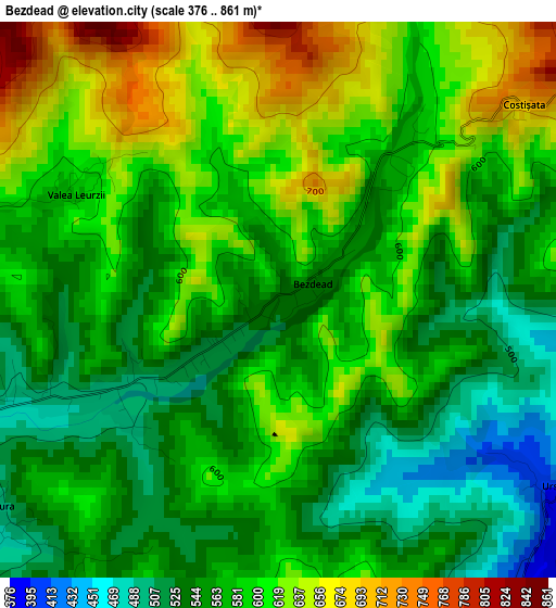
Below is the Elevation map of Bezdead, which displays elevation range with different colors. Scale of the first map is from 376 to 861 m (1234 to 2825 ft) with average elevation of 581.4 meters (=1907 ft) [note 1]
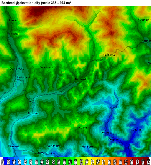
These maps also provides idea of topography and contour of this city, they are displayed at different zoom levels. More info about maps, scale and edge coordinates you can find below images.
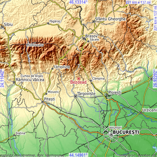
| \ | Map #1 | Map #2 | Topo.Map |
| Scale [m] | 376..861 m | 333..974 m | × |
| Scale [ft] | 1234..2825 ft | 1093..3196 ft | × |
| Average | 581.4 m = 1907 ft | 592.5 m = 1944 ft | × |
| Width | 6.89 km = 4.3 mi | 13.78 km = 8.6 mi | 220.5 km = 137 mi |
| Height | 6.89 km = 4.3 mi | 13.78 km = 8.6 mi | 220.5 km = 137 mi |
| ↑Max Latitude | 45.180984° | 45.211951° | 46.13314° |
| Latitude at center | 45.15° | 45.15° | 45.15° |
| ↓Min Latitude | 45.118999° | 45.087981° | 44.14961° |
| ← Min Longitude | 25.472725° | 25.428779° | 24.11042° |
| Longitude center | 25.51667° | 25.51667° | 25.51667° |
| →Max Longitude | 25.560615° | 25.604561° | 26.92292° |
Nearby cities:
Cities around Bezdead sort by population:
• Fieni elevation 486 m
8.1 km,  256°
256°
• Buciumeni 475 m
5.2 km,  270°
270°
• Pietroşiţa 575 m
7.5 km,  299°
299°
• Vişineşti 493 m
6.1 km,  154°
154°
• Adunaţi 546 m
8.1 km,  103°
103°
• Vârfuri 512 m
5.6 km,  180°
180°
• Valea Leurzii 580 m
2.8 km, 298°
• Dealu Mare 508 m
5.5 km,  282°
282°
• Lunca 563 m
8 km,  314°
314°
• Ocina de Sus 660 m
8.6 km,  48°
48°
• Bădeni 503 m
8.9 km, 271°
• Dealu Frumos 673 m
9 km, 296°
Multilingual:
 En español:
Bezdead elevación 534 m.
 En France:
Bezdead élévation 534 m.


Sources and notes:
- [note 1] Map square and city borders are not equal. Map elevation data is calculated only from area inside that square.
- [src 1] Elevation data from geonames database provided with same terms of usage.
- [src 2] The elevation map of Bezdead is generated using elevation data from NASA's 3 arcsec (90m) resolution SRTM data.
- [src 3] Base (background) map © OpenStreetMap contributors tiles are generated by Geofabrik and OpenTopoMap.
Copyright & License:
This Bezdead Elevation Map is licensed under CC BY-SA. You may reuse any part from this page, if you give a proper credit by linking to this URL:
 More info on terms of use page.