Adunaţi elevation
Adunaţi (Prahova, Comuna Adunaţi), Romania elevation is 546 meters and Adunaţi elevation in feet is 1791 ft above sea level [src 1]. Adunaţi is a seat of a second-order administrative division (feature code) with elevation that is 294 meters (965 ft) bigger than average city elevation in Romania.
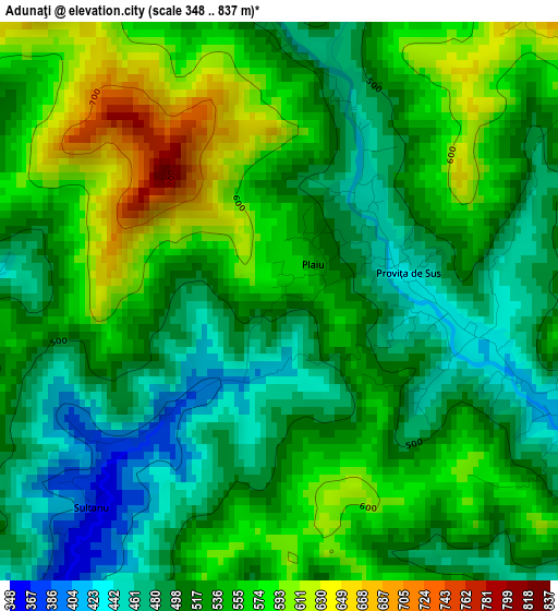
Below is the Elevation map of Adunaţi, which displays elevation range with different colors. Scale of the first map is from 348 to 837 m (1142 to 2746 ft) with average elevation of 528.9 meters (=1735 ft) [note 1]
These maps also provides idea of topography and contour of this city, they are displayed at different zoom levels. More info about maps, scale and edge coordinates you can find below images.
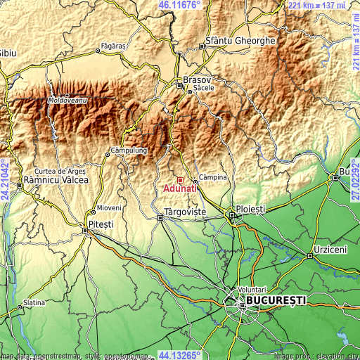
| \ | Map #1 | Topo.Map |
| Scale [m] | 348..837 m | × |
| Scale [ft] | 1142..2746 ft | × |
| Average | 528.9 m = 1735 ft | × |
| Width | 6.89 km = 4.3 mi | 220.6 km = 137.1 mi |
| Height | 6.89 km = 4.3 mi | 220.6 km = 137.1 mi |
| ↑Max Latitude | 45.164323° | 46.11676° |
| Latitude at center | 45.13333° | 45.13333° |
| ↓Min Latitude | 45.10232° | 44.13265° |
| ← Min Longitude | 25.572725° | 24.21042° |
| Longitude center | 25.61667° | 25.61667° |
| →Max Longitude | 25.660615° | 27.02292° |
Nearby cities:
Cities around Adunaţi sort by population:
• Breaza elevation 548 m
6.8 km,  35°
35°
• Breaza de Sus 571 m
7.9 km,  22°
22°
• Poiana Câmpina 571 m
5.2 km,  90°
90°
• Cornu de Sus 517 m
7.5 km,  60°
60°
• Cornu de Jos 496 m
7.4 km,  69°
69°
• Proviţa de Jos 551 m
3.2 km,  125°
125°
• Vişineşti 493 m
6.4 km,  234°
234°
• Proviţa de Sus 470 m
1.3 km, 90°
• Breaza de Jos 511 m
6.3 km,  47°
47°
• Ocina de Sus 660 m
7.6 km,  349°
349°
• Valea Târsei 493 m
5 km,  14°
14°
• Drăgăneasa 419 m
6 km,  122°
122°
Multilingual:
 En español:
Adunaţi elevación 546 m.
 En France:
Adunaţi élévation 546 m.


Sources and notes:
- [note 1] Map square and city borders are not equal. Map elevation data is calculated only from area inside that square.
- [src 1] Elevation data from geonames database provided with same terms of usage.
- [src 2] The elevation map of Adunaţi is generated using elevation data from NASA's 3 arcsec (90m) resolution SRTM data.
- [src 3] Base (background) map © OpenStreetMap contributors tiles are generated by Geofabrik and OpenTopoMap.
Copyright & License:
This Adunaţi Elevation Map is licensed under CC BY-SA. You may reuse any part from this page, if you give a proper credit by linking to this URL:
 More info on terms of use page.