Bâscoveni elevation
Bâscoveni (Teleorman, Comuna Gălăţeni), Romania elevation is 110 meters and Bâscoveni elevation in feet is 361 ft above sea level [src 1]. Bâscoveni is a populated place (feature code) with elevation that is 142 meters (466 ft) smaller than average city elevation in Romania.
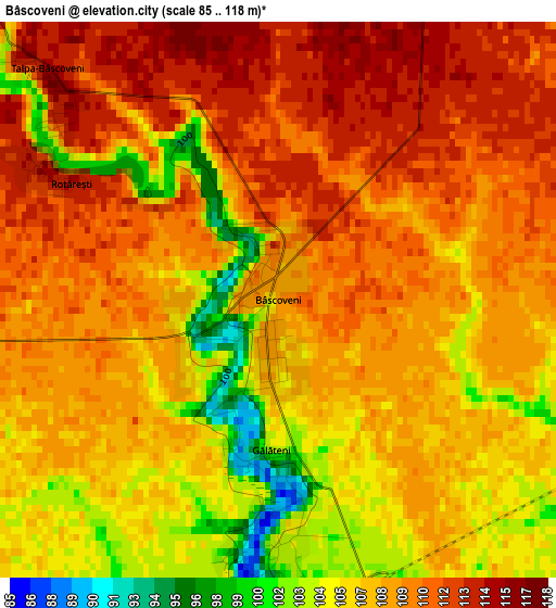
Below is the Elevation map of Bâscoveni, which displays elevation range with different colors. Scale of the first map is from 85 to 118 m (279 to 387 ft) with average elevation of 108.1 meters (=355 ft) [note 1]
These maps also provides idea of topography and contour of this city, they are displayed at different zoom levels. More info about maps, scale and edge coordinates you can find below images.
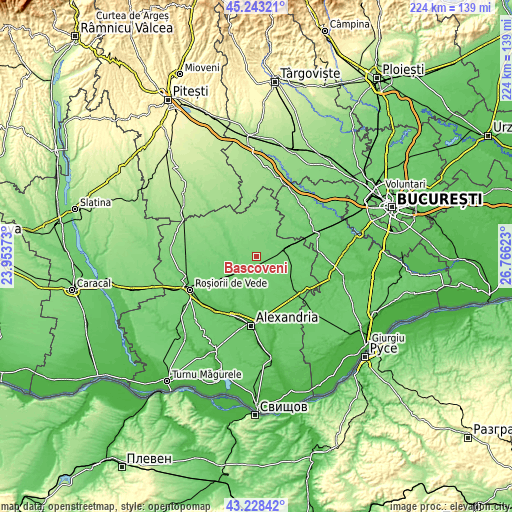
| \ | Map #1 | Topo.Map |
| Scale [m] | 85..118 m | × |
| Scale [ft] | 279..387 ft | × |
| Average | 108.1 m = 355 ft | × |
| Width | 7 km = 4.3 mi | 224 km = 139.2 mi |
| Height | 7 km = 4.3 mi | 224 km = 139.2 mi |
| ↑Max Latitude | 44.275913° | 45.24321° |
| Latitude at center | 44.24444° | 44.24444° |
| ↓Min Latitude | 44.21295° | 43.22842° |
| ← Min Longitude | 25.316035° | 23.95373° |
| Longitude center | 25.35998° | 25.35998° |
| →Max Longitude | 25.403925° | 26.76623° |
Nearby cities:
Cities around Bâscoveni sort by population:
• Orbeasca de Sus elevation 70 m
11.1 km,  198°
198°
• Băbăiţa 93 m
8.8 km,  167°
167°
• Blejeşti 99 m
10.5 km,  53°
53°
• Trivalea-Moşteni 90 m
10.4 km,  283°
283°
• Olteni 75 m
9.1 km,  221°
221°
• Gălăţeni 105 m
3.2 km,  194°
194°
• Cosmeşti 112 m
6.5 km,  16°
16°
• Frăsinet 80 m
7.3 km, 165°
• Talpa-Trivalea 119 m
7.5 km,  305°
305°
• Ciuperceni 117 m
8.3 km,  10°
10°
• Perii Broșteni 79 m
8.9 km,  239°
239°
• Talpa-Ogrăzile 118 m
7.1 km, 311°
Multilingual:
 En español:
Bâscoveni elevación 110 m.
 En France:
Bâscoveni élévation 110 m.
 Auf Deutsch:
Bâscoveni höhe über dem Meeresspiegel ist 110 m.

Sources and notes:
- [note 1] Map square and city borders are not equal. Map elevation data is calculated only from area inside that square.
- [src 1] Elevation data from geonames database provided with same terms of usage.
- [src 2] The elevation map of Bâscoveni is generated using elevation data from NASA's 3 arcsec (90m) resolution SRTM data.
- [src 3] Base (background) map © OpenStreetMap contributors tiles are generated by Geofabrik and OpenTopoMap.
Copyright & License:
This Bâscoveni Elevation Map is licensed under CC BY-SA. You may reuse any part from this page, if you give a proper credit by linking to this URL:
 More info on terms of use page.