Bisoca elevation
Bisoca (Buzău, Comuna Bisoca), Romania elevation is 865 meters and Bisoca elevation in feet is 2838 ft above sea level [src 1]. Bisoca is a seat of a second-order administrative division (feature code) with elevation that is 613 meters (2011 ft) bigger than average city elevation in Romania.
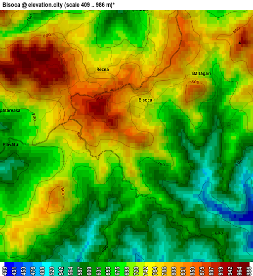
Below is the Elevation map of Bisoca, which displays elevation range with different colors. Scale of the first map is from 409 to 986 m (1342 to 3235 ft) with average elevation of 702.5 meters (=2305 ft) [note 1]
These maps also provides idea of topography and contour of this city, they are displayed at different zoom levels. More info about maps, scale and edge coordinates you can find below images.
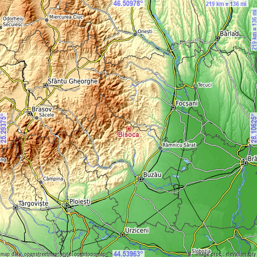
| \ | Map #1 | Topo.Map |
| Scale [m] | 409..986 m | × |
| Scale [ft] | 1342..3235 ft | × |
| Average | 702.5 m = 2305 ft | × |
| Width | 6.85 km = 4.3 mi | 219.1 km = 136.1 mi |
| Height | 6.85 km = 4.3 mi | 219 km = 136.1 mi |
| ↑Max Latitude | 45.564105° | 46.50978° |
| Latitude at center | 45.53333° | 45.53333° |
| ↓Min Latitude | 45.502538° | 44.53963° |
| ← Min Longitude | 26.656055° | 25.29375° |
| Longitude center | 26.7° | 26.7° |
| →Max Longitude | 26.743945° | 28.10625° |
Nearby cities:
Cities around Bisoca sort by population:
• Lopătari elevation 462 m
10.7 km,  238°
238°
• Vintilă Vodă 439 m
7.5 km,  170°
170°
• Buda 284 m
16 km,  103°
103°
• Grunji 562 m
5.4 km,  226°
226°
• Chiojdeni 489 m
13.1 km,  81°
81°
• Vintileasca 658 m
7.9 km,  19°
19°
• Jitia 620 m
5.7 km,  13°
13°
• Săruleşti 452 m
5.4 km,  133°
133°
• Mărgăriteşti 402 m
15.2 km,  136°
136°
• Chiliile 606 m
13 km,  224°
224°
• Valea Salciei 402 m
10.5 km,  113°
113°
• Mânzăleşti 562 m
5.4 km, 226°
Multilingual:
 En español:
Bisoca elevación 865 m.
 En France:
Bisoca élévation 865 m.


Sources and notes:
- [note 1] Map square and city borders are not equal. Map elevation data is calculated only from area inside that square.
- [src 1] Elevation data from geonames database provided with same terms of usage.
- [src 2] The elevation map of Bisoca is generated using elevation data from NASA's 3 arcsec (90m) resolution SRTM data.
- [src 3] Base (background) map © OpenStreetMap contributors tiles are generated by Geofabrik and OpenTopoMap.
Copyright & License:
This Bisoca Elevation Map is licensed under CC BY-SA. You may reuse any part from this page, if you give a proper credit by linking to this URL:
 More info on terms of use page.