Bogheşti elevation
Bogheşti (Vrancea, Comuna Bogheşti), Romania elevation is 168 meters and Bogheşti elevation in feet is 551 ft above sea level [src 1]. Bogheşti is a seat of a second-order administrative division (feature code) with elevation that is 84 meters (276 ft) smaller than average city elevation in Romania.
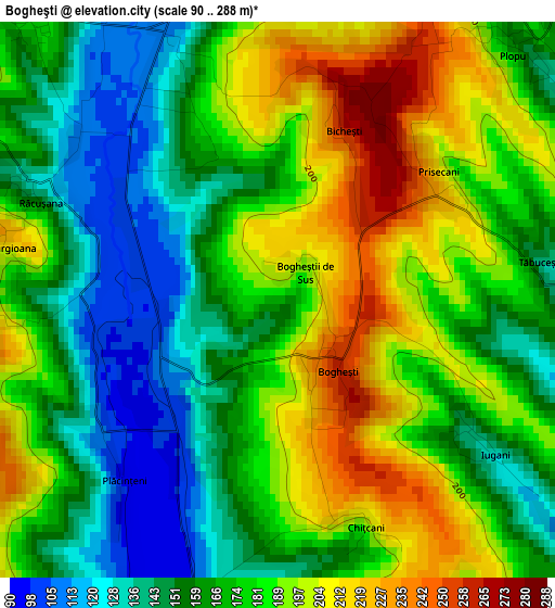
Below is the Elevation map of Bogheşti, which displays elevation range with different colors. Scale of the first map is from 90 to 288 m (295 to 945 ft) with average elevation of 174.8 meters (=573 ft) [note 1]
These maps also provides idea of topography and contour of this city, they are displayed at different zoom levels. More info about maps, scale and edge coordinates you can find below images.
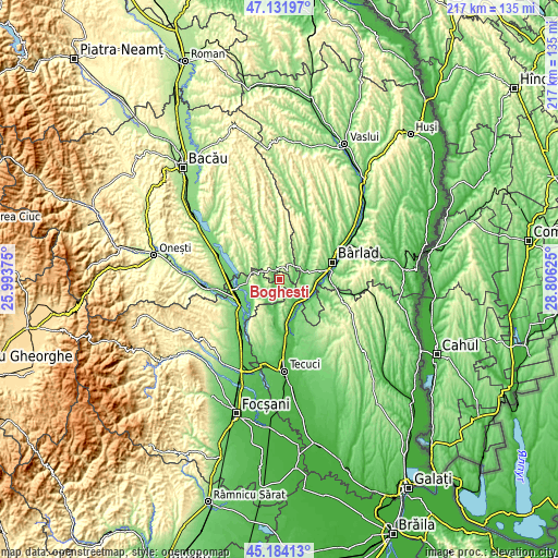
| \ | Map #1 | Topo.Map |
| Scale [m] | 90..288 m | × |
| Scale [ft] | 295..945 ft | × |
| Average | 174.8 m = 573 ft | × |
| Width | 6.77 km = 4.2 mi | 216.6 km = 134.6 mi |
| Height | 6.77 km = 4.2 mi | 216.6 km = 134.6 mi |
| ↑Max Latitude | 46.197096° | 47.13197° |
| Latitude at center | 46.16667° | 46.16667° |
| ↓Min Latitude | 46.136227° | 45.18413° |
| ← Min Longitude | 27.356055° | 25.99375° |
| Longitude center | 27.4° | 27.4° |
| →Max Longitude | 27.443945° | 28.80625° |
Nearby cities:
Cities around Bogheşti sort by population:
• Podu Turcului elevation 114 m
3.9 km,  340°
340°
• Iveşti 72 m
10.4 km,  79°
79°
• Gohor 106 m
11.1 km,  180°
180°
• Glăvăneşti 248 m
9.4 km,  352°
352°
• Toflea 168 m
12.5 km,  203°
203°
• Priponeşti 165 m
9.6 km,  164°
164°
• Tănăsoaia 206 m
7.8 km, 199°
• Coroieşti 179 m
11.3 km,  34°
34°
• Corbiţa 136 m
7.9 km,  256°
256°
• Pogonești 77 m
10.3 km,  98°
98°
• Lespezi 111 m
12.3 km,  266°
266°
• Ciorăști 109 m
7.2 km,  145°
145°
Multilingual:
 En español:
Bogheşti elevación 168 m.
 En France:
Bogheşti élévation 168 m.
 Auf Deutsch:
Bogheşti höhe über dem Meeresspiegel ist 168 m.

Sources and notes:
- [note 1] Map square and city borders are not equal. Map elevation data is calculated only from area inside that square.
- [src 1] Elevation data from geonames database provided with same terms of usage.
- [src 2] The elevation map of Bogheşti is generated using elevation data from NASA's 3 arcsec (90m) resolution SRTM data.
- [src 3] Base (background) map © OpenStreetMap contributors tiles are generated by Geofabrik and OpenTopoMap.
Copyright & License:
This Bogheşti Elevation Map is licensed under CC BY-SA. You may reuse any part from this page, if you give a proper credit by linking to this URL:
 More info on terms of use page.