Botești elevation
Botești (Neamţ, Comuna Boteşti), Romania elevation is 223 meters and Botești elevation in feet is 732 ft above sea level [src 1]. Botești is a seat of a second-order administrative division (feature code) with elevation that is 29 meters (95 ft) smaller than average city elevation in Romania.
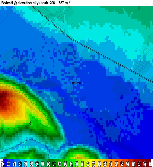
Below is the Elevation map of Botești, which displays elevation range with different colors. Scale of the first map is from 208 to 387 m (682 to 1270 ft) with average elevation of 237.2 meters (=778 ft) [note 1]
These maps also provides idea of topography and contour of this city, they are displayed at different zoom levels. More info about maps, scale and edge coordinates you can find below images.
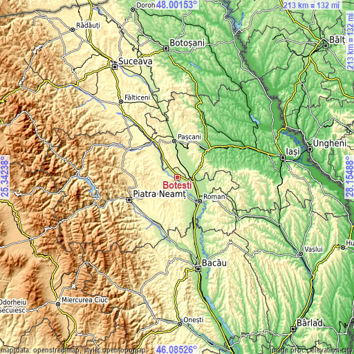
| \ | Map #1 | Topo.Map |
| Scale [m] | 208..387 m | × |
| Scale [ft] | 682..1270 ft | × |
| Average | 237.2 m = 778 ft | × |
| Width | 6.66 km = 4.1 mi | 213.1 km = 132.4 mi |
| Height | 6.66 km = 4.1 mi | 213.1 km = 132.4 mi |
| ↑Max Latitude | 47.081933° | 48.00153° |
| Latitude at center | 47.052° | 47.052° |
| ↓Min Latitude | 47.02205° | 46.08526° |
| ← Min Longitude | 26.704685° | 25.34238° |
| Longitude center | 26.74863° | 26.74863° |
| →Max Longitude | 26.792575° | 28.15488° |
Nearby cities:
Cities around Botești sort by population:
• Săbăoani elevation 223 m
8.6 km,  117°
117°
• Mirceşti 229 m
7.3 km,  61°
61°
• Gherăeşti 210 m
6.5 km,  127°
127°
• Hălăuceşti 256 m
6.6 km,  36°
36°
• Pildești 206 m
8.5 km,  136°
136°
• Tupilaţi 289 m
8.9 km,  280°
280°
• Muncelu de Sus 345 m
8.1 km,  352°
352°
• Nisiporești 244 m
2.9 km,  343°
343°
• Iugani 239 m
6.1 km,  98°
98°
• Ruginoasa 317 m
8 km,  203°
203°
• Barticești 240 m
3.6 km,  69°
69°
• Văleni 277 m
5.1 km,  242°
242°
Multilingual:
 En español:
Botești elevación 223 m.
 En France:
Botești élévation 223 m.


Sources and notes:
- [note 1] Map square and city borders are not equal. Map elevation data is calculated only from area inside that square.
- [src 1] Elevation data from geonames database provided with same terms of usage.
- [src 2] The elevation map of Botești is generated using elevation data from NASA's 3 arcsec (90m) resolution SRTM data.
- [src 3] Base (background) map © OpenStreetMap contributors tiles are generated by Geofabrik and OpenTopoMap.
Copyright & License:
This Botești Elevation Map is licensed under CC BY-SA. You may reuse any part from this page, if you give a proper credit by linking to this URL:
 More info on terms of use page.