Iugani elevation
Iugani (Iaşi, Comuna Mirceşti), Romania elevation is 239 meters and Iugani elevation in feet is 784 ft above sea level [src 1]. Iugani is a populated place (feature code) with elevation that is 13 meters (43 ft) smaller than average city elevation in Romania.
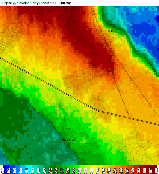
Below is the Elevation map of Iugani, which displays elevation range with different colors. Scale of the first map is from 190 to 260 m (623 to 853 ft) with average elevation of 229.4 meters (=753 ft) [note 1]
These maps also provides idea of topography and contour of this city, they are displayed at different zoom levels. More info about maps, scale and edge coordinates you can find below images.
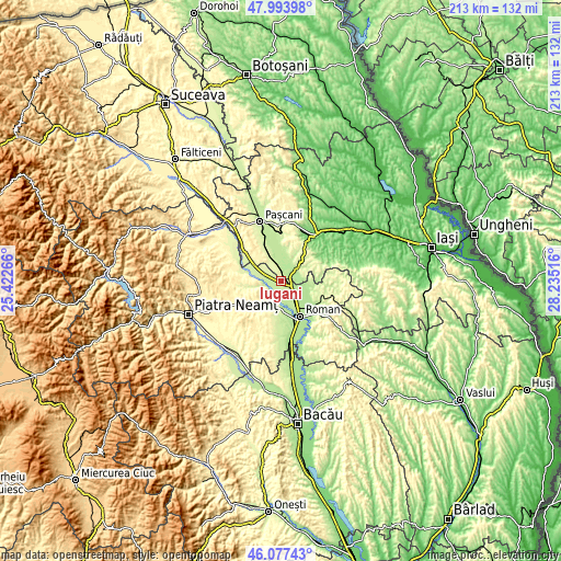
| \ | Map #1 | Topo.Map |
| Scale [m] | 190..260 m | × |
| Scale [ft] | 623..853 ft | × |
| Average | 229.4 m = 753 ft | × |
| Width | 6.66 km = 4.1 mi | 213.1 km = 132.4 mi |
| Height | 6.66 km = 4.1 mi | 213.1 km = 132.4 mi |
| ↑Max Latitude | 47.074247° | 47.99398° |
| Latitude at center | 47.04431° | 47.04431° |
| ↓Min Latitude | 47.014356° | 46.07743° |
| ← Min Longitude | 26.784965° | 25.42266° |
| Longitude center | 26.82891° | 26.82891° |
| →Max Longitude | 26.872855° | 28.23516° |
Nearby cities:
Cities around Iugani sort by population:
• Săbăoani elevation 223 m
3.5 km,  152°
152°
• Mirceşti 229 m
4.4 km,  4°
4°
• Gherăeşti 210 m
3.2 km,  196°
196°
• Hălăuceşti 256 m
6.6 km,  340°
340°
• Butea 187 m
7.1 km,  69°
69°
• Pildești 206 m
5.3 km,  182°
182°
• Nisiporești 244 m
7.8 km,  297°
297°
• Barticești 240 m
3.5 km,  307°
307°
• Răchiteni 191 m
6.8 km,  81°
81°
• Izvoarele 189 m
5.6 km,  92°
92°
• Traian 228 m
8.2 km,  135°
135°
• Botești 223 m
6.1 km,  278°
278°
Multilingual:
 En español:
Iugani elevación 239 m.
 En France:
Iugani élévation 239 m.


Sources and notes:
- [note 1] Map square and city borders are not equal. Map elevation data is calculated only from area inside that square.
- [src 1] Elevation data from geonames database provided with same terms of usage.
- [src 2] The elevation map of Iugani is generated using elevation data from NASA's 3 arcsec (90m) resolution SRTM data.
- [src 3] Base (background) map © OpenStreetMap contributors tiles are generated by Geofabrik and OpenTopoMap.
Copyright & License:
This Iugani Elevation Map is licensed under CC BY-SA. You may reuse any part from this page, if you give a proper credit by linking to this URL:
 More info on terms of use page.