Bragadiru elevation
Bragadiru (Teleorman, Comuna Bragadiru), Romania elevation is 33 meters and Bragadiru elevation in feet is 108 ft above sea level [src 1]. Bragadiru is a seat of a second-order administrative division (feature code) with elevation that is 219 meters (719 ft) smaller than average city elevation in Romania.
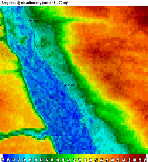
Below is the Elevation map of Bragadiru, which displays elevation range with different colors. Scale of the first map is from 18 to 70 m (59 to 230 ft) with average elevation of 42.4 meters (=139 ft) [note 1]
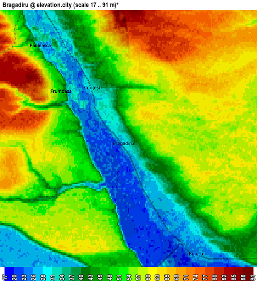
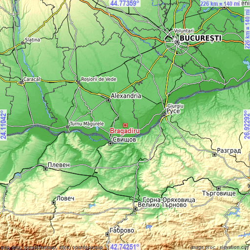
These maps also provides idea of topography and contour of this city, they are displayed at different zoom levels. More info about maps, scale and edge coordinates you can find below images.
| \ | Map #1 | Map #2 | Topo.Map |
| Scale [m] | 18..70 m | 17..91 m | × |
| Scale [ft] | 59..230 ft | 56..299 ft | × |
| Average | 42.4 m = 139 ft | 51.2 m = 168 ft | × |
| Width | 7.06 km = 4.4 mi | 14.11 km = 8.8 mi | 225.8 km = 140.3 mi |
| Height | 7.06 km = 4.4 mi | 14.11 km = 8.8 mi | 225.8 km = 140.3 mi |
| ↑Max Latitude | 43.798397° | 43.830108° | 44.77359° |
| Latitude at center | 43.76667° | 43.76667° | 43.76667° |
| ↓Min Latitude | 43.734926° | 43.703165° | 42.74251° |
| ← Min Longitude | 25.472725° | 25.428779° | 24.11042° |
| Longitude center | 25.51667° | 25.51667° | 25.51667° |
| →Max Longitude | 25.560615° | 25.604561° | 26.92292° |
Nearby cities:
Cities around Bragadiru sort by population:
• Conţeşti elevation 24 m
4.6 km,  324°
324°
• Storobăneasa 35 m
14 km,  337°
337°
• Cervenia 41 m
8.4 km,  331°
331°
• Pietroşani 21 m
11.8 km,  119°
119°
• Năsturelu 20 m
11.8 km,  199°
199°
• Smârdioasa 33 m
11.4 km, 324°
• Frumoasa 50 m
5.5 km,  312°
312°
• Izvoarele 81 m
12.1 km,  297°
297°
• Bujoru 27 m
6.9 km,  144°
144°
• Beiu 53 m
12.9 km, 337°
• Zimnicele 30 m
14.4 km,  215°
215°
• Pietrișu 26 m
13.5 km,  110°
110°
Multilingual:
 En español:
Bragadiru elevación 33 m.
 En France:
Bragadiru élévation 33 m.
 Auf Deutsch:
Bragadiru höhe über dem Meeresspiegel ist 33 m.

Sources and notes:
- [note 1] Map square and city borders are not equal. Map elevation data is calculated only from area inside that square.
- [src 1] Elevation data from geonames database provided with same terms of usage.
- [src 2] The elevation map of Bragadiru is generated using elevation data from NASA's 3 arcsec (90m) resolution SRTM data.
- [src 3] Base (background) map © OpenStreetMap contributors tiles are generated by Geofabrik and OpenTopoMap.
Copyright & License:
This Bragadiru Elevation Map is licensed under CC BY-SA. You may reuse any part from this page, if you give a proper credit by linking to this URL:
 More info on terms of use page.