Conţeşti elevation
Conţeşti (Teleorman, Comuna Conţeşti), Romania elevation is 24 meters and Conţeşti elevation in feet is 79 ft above sea level [src 1]. Conţeşti is a seat of a second-order administrative division (feature code) with elevation that is 228 meters (748 ft) smaller than average city elevation in Romania.
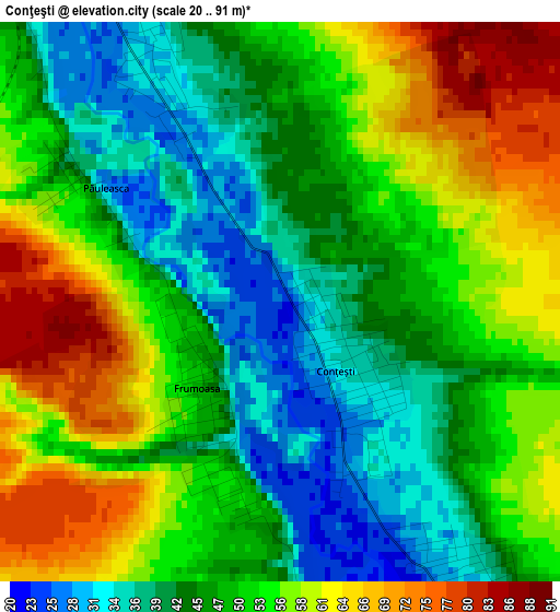
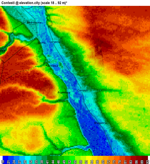
Below is the Elevation map of Conţeşti, which displays elevation range with different colors. Scale of the first map is from 20 to 91 m (66 to 299 ft) with average elevation of 49.9 meters (=164 ft) [note 1]
These maps also provides idea of topography and contour of this city, they are displayed at different zoom levels. More info about maps, scale and edge coordinates you can find below images.
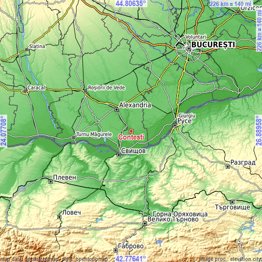
| \ | Map #1 | Map #2 | Topo.Map |
| Scale [m] | 20..91 m | 18..92 m | × |
| Scale [ft] | 66..299 ft | 59..302 ft | × |
| Average | 49.9 m = 164 ft | 58.8 m = 193 ft | × |
| Width | 7.05 km = 4.4 mi | 14.11 km = 8.8 mi | 225.7 km = 140.2 mi |
| Height | 7.05 km = 4.4 mi | 14.11 km = 8.8 mi | 225.7 km = 140.2 mi |
| ↑Max Latitude | 43.83171° | 43.863402° | 44.80635° |
| Latitude at center | 43.8° | 43.8° | 43.8° |
| ↓Min Latitude | 43.768274° | 43.73653° | 42.77641° |
| ← Min Longitude | 25.439385° | 25.395439° | 24.07708° |
| Longitude center | 25.48333° | 25.48333° | 25.48333° |
| →Max Longitude | 25.527275° | 25.571221° | 26.88958° |
Nearby cities:
Cities around Conţeşti sort by population:
• Ţigăneşti elevation 38 m
14.5 km,  319°
319°
• Bragadiru 33 m
4.6 km,  144°
144°
• Storobăneasa 35 m
9.6 km,  343°
343°
• Cervenia 41 m
3.9 km, 340°
• Brânceni 33 m
11.4 km, 324°
• Smârdioasa 33 m
6.9 km, 324°
• Frumoasa 50 m
1.3 km,  270°
270°
• Izvoarele 81 m
8.2 km,  283°
283°
• Bujoru 27 m
11.4 km, 144°
• Beiu 53 m
8.5 km, 344°
• Cernetu 34 m
12.1 km,  349°
349°
• Valea Părului 38 m
13.1 km, 353°
Multilingual:
 En español:
Conţeşti elevación 24 m.
 En France:
Conţeşti élévation 24 m.


Sources and notes:
- [note 1] Map square and city borders are not equal. Map elevation data is calculated only from area inside that square.
- [src 1] Elevation data from geonames database provided with same terms of usage.
- [src 2] The elevation map of Conţeşti is generated using elevation data from NASA's 3 arcsec (90m) resolution SRTM data.
- [src 3] Base (background) map © OpenStreetMap contributors tiles are generated by Geofabrik and OpenTopoMap.
Copyright & License:
This Conţeşti Elevation Map is licensed under CC BY-SA. You may reuse any part from this page, if you give a proper credit by linking to this URL:
 More info on terms of use page.