Brusturi elevation
Brusturi (Neamţ, Comuna Brusturi-Drăgăneşti), Romania elevation is 335 meters and Brusturi elevation in feet is 1099 ft above sea level [src 1]. Brusturi is a populated place (feature code) with elevation that is 83 meters (272 ft) bigger than average city elevation in Romania.
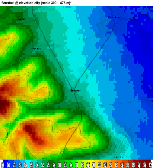
Below is the Elevation map of Brusturi, which displays elevation range with different colors. Scale of the first map is from 300 to 476 m (984 to 1562 ft) with average elevation of 352.1 meters (=1155 ft) [note 1]
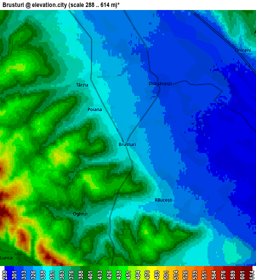
These maps also provides idea of topography and contour of this city, they are displayed at different zoom levels. More info about maps, scale and edge coordinates you can find below images.
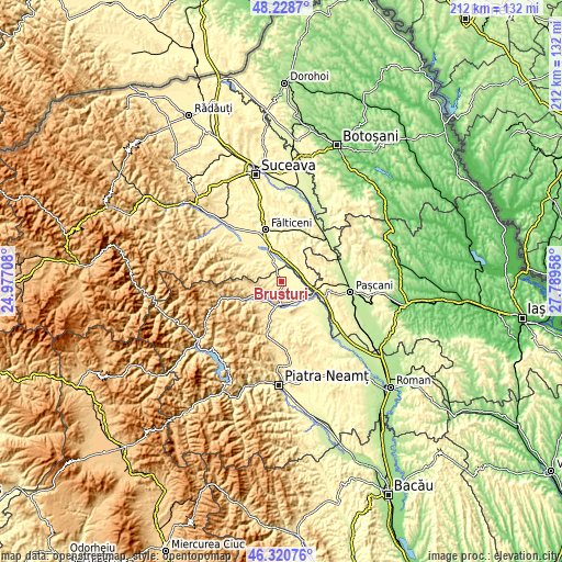
| \ | Map #1 | Map #2 | Topo.Map |
| Scale [m] | 300..476 m | 288..614 m | × |
| Scale [ft] | 984..1562 ft | 945..2014 ft | × |
| Average | 352.1 m = 1155 ft | 360.2 m = 1182 ft | × |
| Width | 6.63 km = 4.1 mi | 13.26 km = 8.2 mi | 212.1 km = 131.8 mi |
| Height | 6.63 km = 4.1 mi | 13.26 km = 8.2 mi | 212.1 km = 131.8 mi |
| ↑Max Latitude | 47.313133° | 47.342919° | 48.2287° |
| Latitude at center | 47.28333° | 47.28333° | 47.28333° |
| ↓Min Latitude | 47.25351° | 47.223674° | 46.32076° |
| ← Min Longitude | 26.339385° | 26.295439° | 24.97708° |
| Longitude center | 26.38333° | 26.38333° | 26.38333° |
| →Max Longitude | 26.427275° | 26.471221° | 27.78958° |
Nearby cities:
Cities around Brusturi sort by population:
• Târgu Neamţ elevation 361 m
9.4 km,  187°
187°
• Răuceşti 326 m
4.5 km,  145°
145°
• Forăşti 379 m
9.7 km,  40°
40°
• Boroaia 342 m
8.3 km,  333°
333°
• Humulești 376 m
9.7 km, 193°
• Oglinzi 397 m
4.4 km,  214°
214°
• Drăguşeni 288 m
7.5 km,  90°
90°
• Nemțișor 444 m
9.7 km,  239°
239°
• Lunca 407 m
8.8 km,  225°
225°
• Dumbrava 316 m
9.6 km,  141°
141°
• Oniceni 322 m
7.5 km,  52°
52°
• Drăgănești 308 m
3.3 km,  30°
30°
Multilingual:
 En español:
Brusturi elevación 335 m.
 En France:
Brusturi élévation 335 m.
 Auf Deutsch:
Brusturi höhe über dem Meeresspiegel ist 335 m.

Sources and notes:
- [note 1] Map square and city borders are not equal. Map elevation data is calculated only from area inside that square.
- [src 1] Elevation data from geonames database provided with same terms of usage.
- [src 2] The elevation map of Brusturi is generated using elevation data from NASA's 3 arcsec (90m) resolution SRTM data.
- [src 3] Base (background) map © OpenStreetMap contributors tiles are generated by Geofabrik and OpenTopoMap.
Copyright & License:
This Brusturi Elevation Map is licensed under CC BY-SA. You may reuse any part from this page, if you give a proper credit by linking to this URL:
 More info on terms of use page.