Lunca elevation
Lunca (Neamţ, Comuna Vânători Neamţ), Romania elevation is 407 meters and Lunca elevation in feet is 1335 ft above sea level [src 1]. Lunca is a populated place (feature code) with elevation that is 155 meters (509 ft) bigger than average city elevation in Romania.
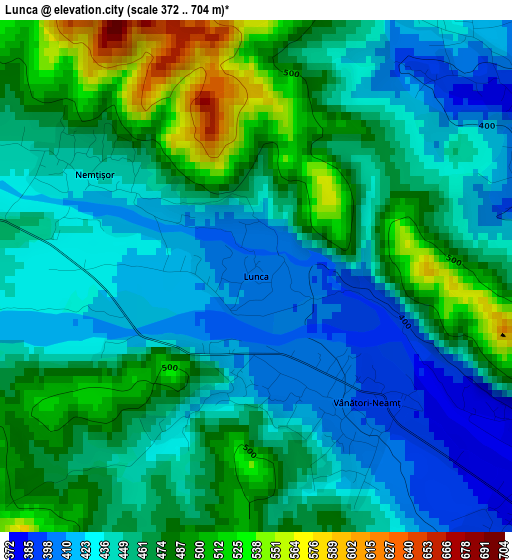
Below is the Elevation map of Lunca, which displays elevation range with different colors. Scale of the first map is from 372 to 704 m (1220 to 2310 ft) with average elevation of 458.1 meters (=1503 ft) [note 1]
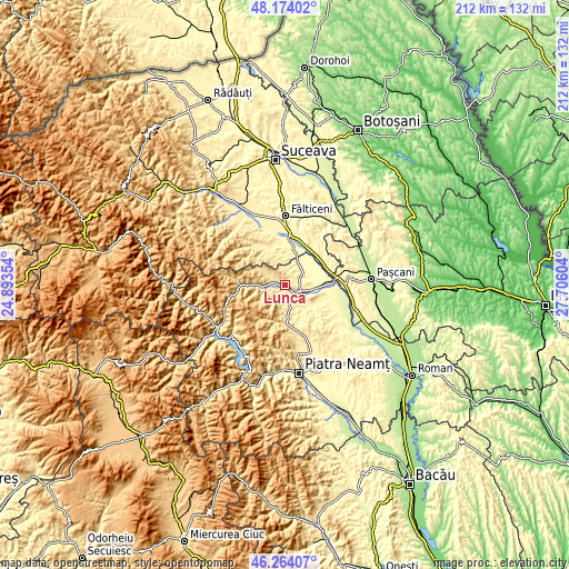
These maps also provides idea of topography and contour of this city, they are displayed at different zoom levels. More info about maps, scale and edge coordinates you can find below images.
| \ | Map #1 | Topo.Map |
| Scale [m] | 372..704 m | × |
| Scale [ft] | 1220..2310 ft | × |
| Average | 458.1 m = 1503 ft | × |
| Width | 6.64 km = 4.1 mi | 212.4 km = 132 mi |
| Height | 6.64 km = 4.1 mi | 212.4 km = 132 mi |
| ↑Max Latitude | 47.257484° | 48.17402° |
| Latitude at center | 47.22765° | 47.22765° |
| ↓Min Latitude | 47.197799° | 46.26407° |
| ← Min Longitude | 26.255845° | 24.89354° |
| Longitude center | 26.29979° | 26.29979° |
| →Max Longitude | 26.343735° | 27.70604° |
Nearby cities:
Cities around Lunca sort by population:
• Târgu Neamţ elevation 361 m
5.9 km,  121°
121°
• Vânători-Neamţ 445 m
3.3 km,  157°
157°
• Răuceşti 326 m
9.2 km,  74°
74°
• Brusturi 335 m
8.8 km,  45°
45°
• Agapia 470 m
6.9 km,  190°
190°
• Humulești 376 m
5.1 km,  129°
129°
• Oglinzi 397 m
4.6 km,  56°
56°
• Topolița 354 m
9.2 km,  136°
136°
• Nemțișor 444 m
2.5 km,  302°
302°
• Valea Seacă 440 m
9.8 km,  180°
180°
• Valea Arini 478 m
11.2 km, 182°
• Filioara 507 m
7.6 km, 191°
Multilingual:
 En español:
Lunca elevación 407 m.
 En France:
Lunca élévation 407 m.


Sources and notes:
- [note 1] Map square and city borders are not equal. Map elevation data is calculated only from area inside that square.
- [src 1] Elevation data from geonames database provided with same terms of usage.
- [src 2] The elevation map of Lunca is generated using elevation data from NASA's 3 arcsec (90m) resolution SRTM data.
- [src 3] Base (background) map © OpenStreetMap contributors tiles are generated by Geofabrik and OpenTopoMap.
Copyright & License:
This Lunca Elevation Map is licensed under CC BY-SA. You may reuse any part from this page, if you give a proper credit by linking to this URL:
 More info on terms of use page.