Buciumi elevation
Buciumi (Sălaj, Comuna Buciumi), Romania elevation is 374 meters and Buciumi elevation in feet is 1227 ft above sea level [src 1]. Buciumi is a seat of a second-order administrative division (feature code) with elevation that is 122 meters (400 ft) bigger than average city elevation in Romania.
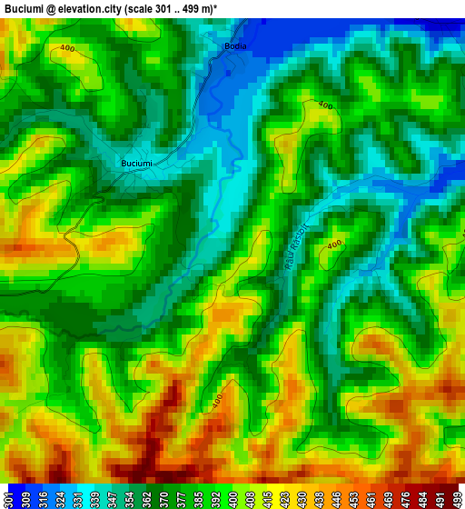
Below is the Elevation map of Buciumi, which displays elevation range with different colors. Scale of the first map is from 301 to 499 m (988 to 1637 ft) with average elevation of 386.1 meters (=1267 ft) [note 1]
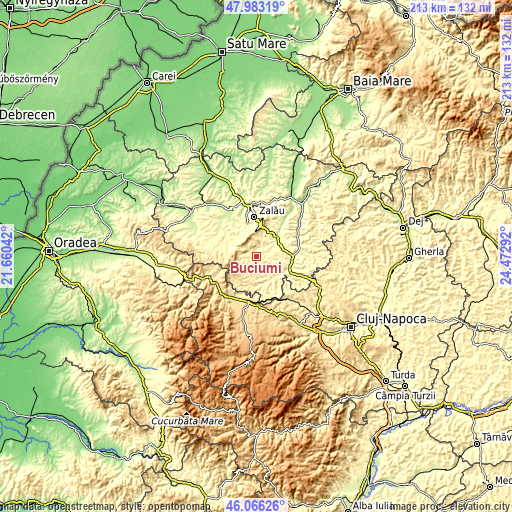
These maps also provides idea of topography and contour of this city, they are displayed at different zoom levels. More info about maps, scale and edge coordinates you can find below images.
| \ | Map #1 | Topo.Map |
| Scale [m] | 301..499 m | × |
| Scale [ft] | 988..1637 ft | × |
| Average | 386.1 m = 1267 ft | × |
| Width | 6.66 km = 4.1 mi | 213.1 km = 132.4 mi |
| Height | 6.66 km = 4.1 mi | 213.1 km = 132.4 mi |
| ↑Max Latitude | 47.063274° | 47.98319° |
| Latitude at center | 47.03333° | 47.03333° |
| ↓Min Latitude | 47.00337° | 46.06626° |
| ← Min Longitude | 23.022725° | 21.66042° |
| Longitude center | 23.06667° | 23.06667° |
| →Max Longitude | 23.110615° | 24.47292° |
Nearby cities:
Cities around Buciumi sort by population:
• Hida elevation 320 m
16.8 km,  77°
77°
• Meseşenii de Jos 292 m
14.4 km,  334°
334°
• Almaşu 313 m
10.9 km,  153°
153°
• Cizer 348 m
14.4 km,  284°
284°
• Cuzăplac 283 m
12.5 km,  126°
126°
• Fildu de Jos 400 m
11.1 km,  180°
180°
• Agrij 303 m
4.5 km,  33°
33°
• Zimbor 303 m
15.6 km,  103°
103°
• Aghireș 273 m
14.7 km,  345°
345°
• Stârciu 353 m
12.6 km,  298°
298°
• Treznea 339 m
8.3 km, 27°
• Românaşi 250 m
11.5 km,  50°
50°
Multilingual:
 En español:
Buciumi elevación 374 m.
 En France:
Buciumi élévation 374 m.


Sources and notes:
- [note 1] Map square and city borders are not equal. Map elevation data is calculated only from area inside that square.
- [src 1] Elevation data from geonames database provided with same terms of usage.
- [src 2] The elevation map of Buciumi is generated using elevation data from NASA's 3 arcsec (90m) resolution SRTM data.
- [src 3] Base (background) map © OpenStreetMap contributors tiles are generated by Geofabrik and OpenTopoMap.
Copyright & License:
This Buciumi Elevation Map is licensed under CC BY-SA. You may reuse any part from this page, if you give a proper credit by linking to this URL:
 More info on terms of use page.