Stârciu elevation
Stârciu (Sălaj, Comuna Horoatu Crasnei), Romania elevation is 353 meters and Stârciu elevation in feet is 1158 ft above sea level [src 1]. Stârciu is a populated place (feature code) with elevation that is 101 meters (331 ft) bigger than average city elevation in Romania.
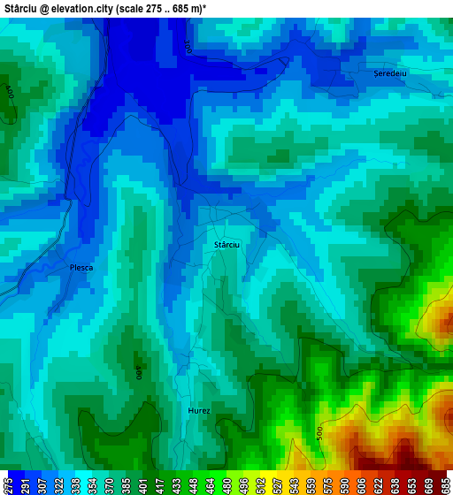
Below is the Elevation map of Stârciu, which displays elevation range with different colors. Scale of the first map is from 275 to 685 m (902 to 2247 ft) with average elevation of 366.6 meters (=1203 ft) [note 1]
These maps also provides idea of topography and contour of this city, they are displayed at different zoom levels. More info about maps, scale and edge coordinates you can find below images.
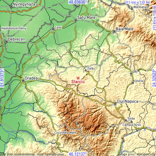
| \ | Map #1 | Topo.Map |
| Scale [m] | 275..685 m | × |
| Scale [ft] | 902..2247 ft | × |
| Average | 366.6 m = 1203 ft | × |
| Width | 6.65 km = 4.1 mi | 212.9 km = 132.3 mi |
| Height | 6.65 km = 4.1 mi | 212.9 km = 132.3 mi |
| ↑Max Latitude | 47.117383° | 48.03636° |
| Latitude at center | 47.08747° | 47.08747° |
| ↓Min Latitude | 47.05754° | 46.12137° |
| ← Min Longitude | 22.876035° | 21.51373° |
| Longitude center | 22.91998° | 22.91998° |
| →Max Longitude | 22.963925° | 24.32623° |
Nearby cities:
Cities around Stârciu sort by population:
• Crasna elevation 302 m
8.9 km,  350°
350°
• Meseşenii de Jos 292 m
8.4 km,  34°
34°
• Horoatu Crasnei 265 m
5.8 km,  331°
331°
• Buciumi 374 m
12.6 km,  118°
118°
• Cizer 348 m
3.6 km,  230°
230°
• Bănişor 306 m
6.5 km,  286°
286°
• Peceiu 272 m
6 km,  313°
313°
• Marin 296 m
9.4 km,  298°
298°
• Aghireș 273 m
11.1 km,  41°
41°
• Mal 351 m
8.2 km,  256°
256°
• Sâg 352 m
10.6 km, 262°
• Vârşolţ 224 m
12.6 km,  4°
4°
Multilingual:
 En español:
Stârciu elevación 353 m.
 En France:
Stârciu élévation 353 m.


Sources and notes:
- [note 1] Map square and city borders are not equal. Map elevation data is calculated only from area inside that square.
- [src 1] Elevation data from geonames database provided with same terms of usage.
- [src 2] The elevation map of Stârciu is generated using elevation data from NASA's 3 arcsec (90m) resolution SRTM data.
- [src 3] Base (background) map © OpenStreetMap contributors tiles are generated by Geofabrik and OpenTopoMap.
Copyright & License:
This Stârciu Elevation Map is licensed under CC BY-SA. You may reuse any part from this page, if you give a proper credit by linking to this URL:
 More info on terms of use page.