Budești elevation
Budești (Vrancea, Comuna Coteşti), Romania elevation is 213 meters and Budești elevation in feet is 699 ft above sea level [src 1]. Budești is a populated place (feature code) with elevation that is 39 meters (128 ft) smaller than average city elevation in Romania.
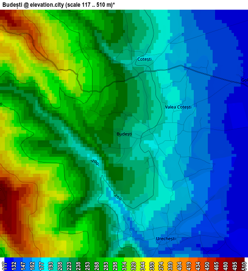
Below is the Elevation map of Budești, which displays elevation range with different colors. Scale of the first map is from 117 to 510 m (384 to 1673 ft) with average elevation of 234.9 meters (=771 ft) [note 1]
These maps also provides idea of topography and contour of this city, they are displayed at different zoom levels. More info about maps, scale and edge coordinates you can find below images.
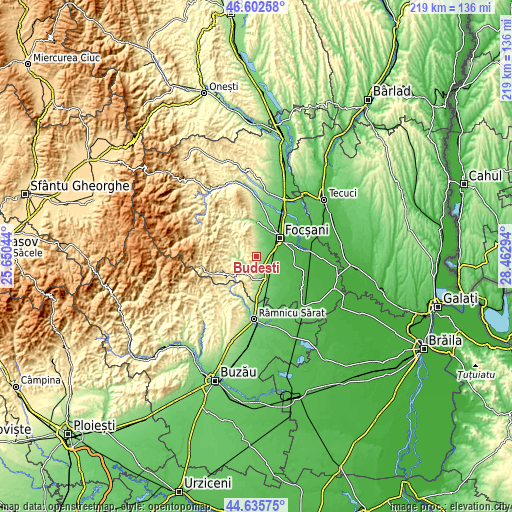
| \ | Map #1 | Topo.Map |
| Scale [m] | 117..510 m | × |
| Scale [ft] | 384..1673 ft | × |
| Average | 234.9 m = 771 ft | × |
| Width | 6.83 km = 4.2 mi | 218.7 km = 135.9 mi |
| Height | 6.83 km = 4.2 mi | 218.7 km = 135.9 mi |
| ↑Max Latitude | 45.658513° | 46.60258° |
| Latitude at center | 45.62779° | 45.62779° |
| ↓Min Latitude | 45.59705° | 44.63575° |
| ← Min Longitude | 27.012745° | 25.65044° |
| Longitude center | 27.05669° | 27.05669° |
| →Max Longitude | 27.100635° | 28.46294° |
Nearby cities:
Cities around Budești sort by population:
• Gugeşti elevation 81 m
9 km,  138°
138°
• Urecheşti 164 m
3.2 km,  165°
165°
• Coteşti 246 m
2.5 km,  348°
348°
• Goleşti 69 m
7.4 km,  54°
54°
• Slobozia-Câmpineanca 70 m
10 km,  36°
36°
• Gura Caliţei 166 m
5.8 km,  212°
212°
• Cârligele 119 m
7 km,  28°
28°
• Poiana Cristei 381 m
6.2 km,  293°
293°
• Popești 159 m
4 km,  154°
154°
• Câmpineanca 82 m
10.9 km, 30°
• Bordeşti 230 m
8.7 km,  183°
183°
• Ceardac 54 m
9.7 km,  61°
61°
Multilingual:
 En español:
Budești elevación 213 m.
 En France:
Budești élévation 213 m.


Sources and notes:
- [note 1] Map square and city borders are not equal. Map elevation data is calculated only from area inside that square.
- [src 1] Elevation data from geonames database provided with same terms of usage.
- [src 2] The elevation map of Budești is generated using elevation data from NASA's 3 arcsec (90m) resolution SRTM data.
- [src 3] Base (background) map © OpenStreetMap contributors tiles are generated by Geofabrik and OpenTopoMap.
Copyright & License:
This Budești Elevation Map is licensed under CC BY-SA. You may reuse any part from this page, if you give a proper credit by linking to this URL:
 More info on terms of use page.