Bujoreni elevation
Bujoreni (Vâlcea, Comuna Bujoreni), Romania elevation is 407 meters and Bujoreni elevation in feet is 1335 ft above sea level [src 1]. Bujoreni is a seat of a second-order administrative division (feature code) with elevation that is 155 meters (509 ft) bigger than average city elevation in Romania.
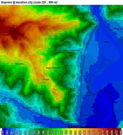
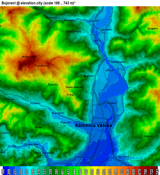
Below is the Elevation map of Bujoreni, which displays elevation range with different colors. Scale of the first map is from 225 to 690 m (738 to 2264 ft) with average elevation of 373.1 meters (=1224 ft) [note 1]
These maps also provides idea of topography and contour of this city, they are displayed at different zoom levels. More info about maps, scale and edge coordinates you can find below images.
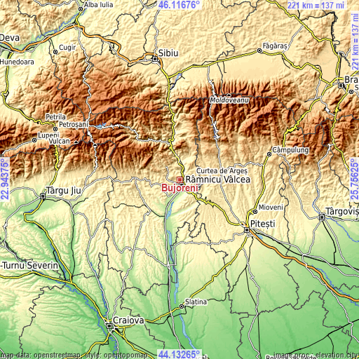
| \ | Map #1 | Map #2 | Topo.Map |
| Scale [m] | 225..690 m | 188..743 m | × |
| Scale [ft] | 738..2264 ft | 617..2438 ft | × |
| Average | 373.1 m = 1224 ft | 382.6 m = 1255 ft | × |
| Width | 6.89 km = 4.3 mi | 13.79 km = 8.6 mi | 220.6 km = 137.1 mi |
| Height | 6.89 km = 4.3 mi | 13.79 km = 8.6 mi | 220.6 km = 137.1 mi |
| ↑Max Latitude | 45.164323° | 45.1953° | 46.11676° |
| Latitude at center | 45.13333° | 45.13333° | 45.13333° |
| ↓Min Latitude | 45.10232° | 45.071293° | 44.13265° |
| ← Min Longitude | 24.306055° | 24.262109° | 22.94375° |
| Longitude center | 24.35° | 24.35° | 24.35° |
| →Max Longitude | 24.393945° | 24.437891° | 25.75625° |
Nearby cities:
Cities around Bujoreni sort by population:
• Râmnicu Vâlcea elevation 237 m
3.9 km,  160°
160°
• Budeşti 316 m
9.6 km, 164°
• Păuşeşti-Măglaşi 342 m
7.8 km,  270°
270°
• Goranu 236 m
4.1 km,  139°
139°
• Muereasca 378 m
5.7 km,  346°
346°
• Vlădeşti 284 m
4.3 km,  244°
244°
• Stolniceni 217 m
11 km,  198°
198°
• Copăcelu 237 m
7.9 km, 202°
• Gura Suhașului 261 m
6.4 km,  218°
218°
• Olănești 403 m
8.9 km,  307°
307°
• Runcu 391 m
8.7 km,  64°
64°
• Dăești 296 m
8.1 km,  20°
20°
Multilingual:
 En español:
Bujoreni elevación 407 m.
 En France:
Bujoreni élévation 407 m.
 Auf Deutsch:
Bujoreni höhe über dem Meeresspiegel ist 407 m.

Sources and notes:
- [note 1] Map square and city borders are not equal. Map elevation data is calculated only from area inside that square.
- [src 1] Elevation data from geonames database provided with same terms of usage.
- [src 2] The elevation map of Bujoreni is generated using elevation data from NASA's 3 arcsec (90m) resolution SRTM data.
- [src 3] Base (background) map © OpenStreetMap contributors tiles are generated by Geofabrik and OpenTopoMap.
Copyright & License:
This Bujoreni Elevation Map is licensed under CC BY-SA. You may reuse any part from this page, if you give a proper credit by linking to this URL:
 More info on terms of use page.