Călina elevation
Călina (Vâlcea, Comuna Prundeni), Romania elevation is 171 meters and Călina elevation in feet is 561 ft above sea level [src 1]. Călina is a populated place (feature code) with elevation that is 81 meters (266 ft) smaller than average city elevation in Romania.
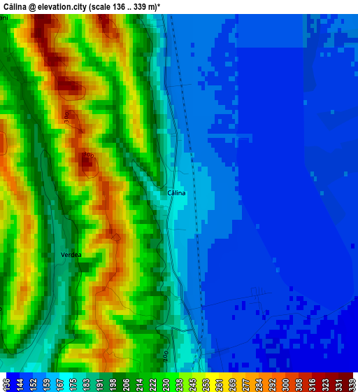
Below is the Elevation map of Călina, which displays elevation range with different colors. Scale of the first map is from 136 to 339 m (446 to 1112 ft) with average elevation of 191.1 meters (=627 ft) [note 1]
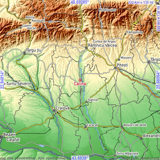
These maps also provides idea of topography and contour of this city, they are displayed at different zoom levels. More info about maps, scale and edge coordinates you can find below images.
| \ | Map #1 | Topo.Map |
| Scale [m] | 136..339 m | × |
| Scale [ft] | 446..1112 ft | × |
| Average | 191.1 m = 627 ft | × |
| Width | 6.95 km = 4.3 mi | 222.3 km = 138.1 mi |
| Height | 6.95 km = 4.3 mi | 222.3 km = 138.1 mi |
| ↑Max Latitude | 44.733277° | 45.69295° |
| Latitude at center | 44.70205° | 44.70205° |
| ↓Min Latitude | 44.670806° | 43.6939° |
| ← Min Longitude | 24.210445° | 22.84814° |
| Longitude center | 24.25439° | 24.25439° |
| →Max Longitude | 24.298335° | 25.66064° |
Nearby cities:
Cities around Călina sort by population:
• Drăgăşani elevation 155 m
5.9 km,  170°
170°
• Prundeni 156 m
3.6 km,  15°
15°
• Ştefăneşti 159 m
9.5 km,  182°
182°
• Verguleasa 142 m
7.6 km,  139°
139°
• Vultureşti 201 m
6 km,  54°
54°
• Creţeni 180 m
6 km,  249°
249°
• Cungrea 211 m
10.9 km,  111°
111°
• Dobrușa 192 m
9.2 km,  203°
203°
• Zlătărei 156 m
8 km, 178°
• Dumitrești 153 m
5.3 km, 112°
• Mitrofani 211 m
4.9 km,  313°
313°
• Sutești 170 m
4.9 km,  220°
220°
Multilingual:
 En español:
Călina elevación 171 m.
 En France:
Călina élévation 171 m.


Sources and notes:
- [note 1] Map square and city borders are not equal. Map elevation data is calculated only from area inside that square.
- [src 1] Elevation data from geonames database provided with same terms of usage.
- [src 2] The elevation map of Călina is generated using elevation data from NASA's 3 arcsec (90m) resolution SRTM data.
- [src 3] Base (background) map © OpenStreetMap contributors tiles are generated by Geofabrik and OpenTopoMap.
Copyright & License:
This Călina Elevation Map is licensed under CC BY-SA. You may reuse any part from this page, if you give a proper credit by linking to this URL:
 More info on terms of use page.