Prundeni elevation
Prundeni (Vâlcea, Comuna Prundeni), Romania elevation is 156 meters and Prundeni elevation in feet is 512 ft above sea level [src 1]. Prundeni is a seat of a second-order administrative division (feature code) with elevation that is 96 meters (315 ft) smaller than average city elevation in Romania.
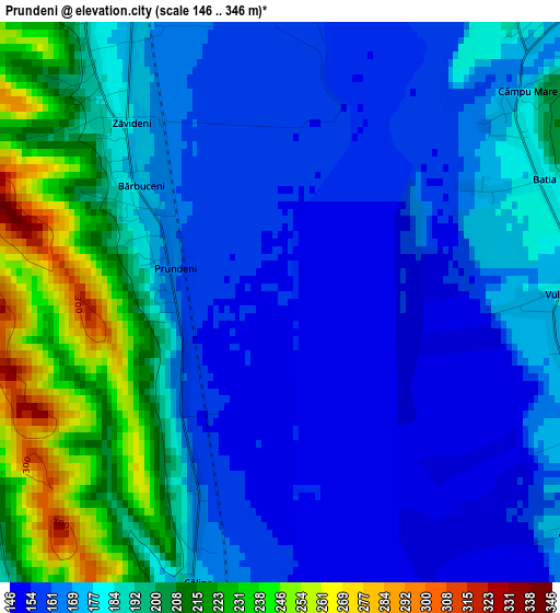
Below is the Elevation map of Prundeni, which displays elevation range with different colors. Scale of the first map is from 146 to 346 m (479 to 1135 ft) with average elevation of 181.1 meters (=594 ft) [note 1]
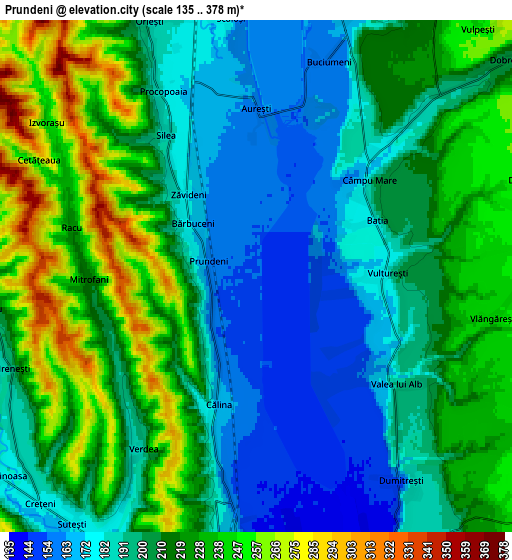
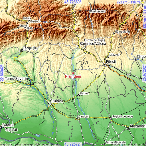
These maps also provides idea of topography and contour of this city, they are displayed at different zoom levels. More info about maps, scale and edge coordinates you can find below images.
| \ | Map #1 | Map #2 | Topo.Map |
| Scale [m] | 146..346 m | 135..378 m | × |
| Scale [ft] | 479..1135 ft | 443..1240 ft | × |
| Average | 181.1 m = 594 ft | 209.1 m = 686 ft | × |
| Width | 6.94 km = 4.3 mi | 13.88 km = 8.6 mi | 222.2 km = 138.1 mi |
| Height | 6.94 km = 4.3 mi | 13.88 km = 8.6 mi | 222.1 km = 138 mi |
| ↑Max Latitude | 44.76454° | 44.795733° | 45.72369° |
| Latitude at center | 44.73333° | 44.73333° | 44.73333° |
| ↓Min Latitude | 44.702103° | 44.67086° | 43.72572° |
| ← Min Longitude | 24.222725° | 24.178779° | 22.86042° |
| Longitude center | 24.26667° | 24.26667° | 24.26667° |
| →Max Longitude | 24.310615° | 24.354561° | 25.67292° |
Nearby cities:
Cities around Prundeni sort by population:
• Drăgăşani elevation 155 m
9.3 km,  180°
180°
• Verguleasa 142 m
10.1 km,  156°
156°
• Orleşti 220 m
8.4 km,  331°
331°
• Vultureşti 201 m
3.9 km,  90°
90°
• Creţeni 180 m
8.6 km,  229°
229°
• Drăgoeşti 224 m
9.6 km,  15°
15°
• Dobroteasa 332 m
10.8 km,  58°
58°
• Amărăşti 216 m
9.9 km,  291°
291°
• Călina 171 m
3.6 km,  195°
195°
• Dumitrești 153 m
6.8 km,  144°
144°
• Mitrofani 211 m
4.5 km,  269°
269°
• Sutești 170 m
8.3 km,  209°
209°
Multilingual:
 En español:
Prundeni elevación 156 m.
 En France:
Prundeni élévation 156 m.
 Auf Deutsch:
Prundeni höhe über dem Meeresspiegel ist 156 m.

Sources and notes:
- [note 1] Map square and city borders are not equal. Map elevation data is calculated only from area inside that square.
- [src 1] Elevation data from geonames database provided with same terms of usage.
- [src 2] The elevation map of Prundeni is generated using elevation data from NASA's 3 arcsec (90m) resolution SRTM data.
- [src 3] Base (background) map © OpenStreetMap contributors tiles are generated by Geofabrik and OpenTopoMap.
Copyright & License:
This Prundeni Elevation Map is licensed under CC BY-SA. You may reuse any part from this page, if you give a proper credit by linking to this URL:
 More info on terms of use page.