Căuaş elevation
Căuaş (Satu Mare, Comuna Căuaş), Romania elevation is 116 meters and Căuaş elevation in feet is 381 ft above sea level [src 1]. Căuaş is a seat of a second-order administrative division (feature code) with elevation that is 136 meters (446 ft) smaller than average city elevation in Romania.
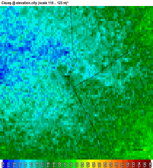
Below is the Elevation map of Căuaş, which displays elevation range with different colors. Scale of the first map is from 110 to 123 m (361 to 404 ft) with average elevation of 116.3 meters (=382 ft) [note 1]
These maps also provides idea of topography and contour of this city, they are displayed at different zoom levels. More info about maps, scale and edge coordinates you can find below images.
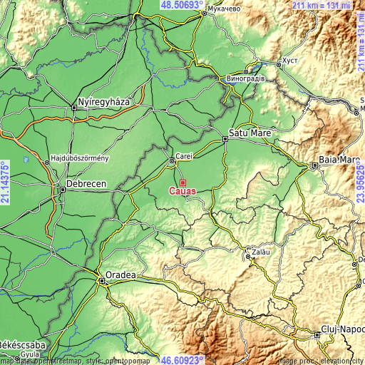
| \ | Map #1 | Topo.Map |
| Scale [m] | 110..123 m | × |
| Scale [ft] | 361..404 ft | × |
| Average | 116.3 m = 382 ft | × |
| Width | 6.59 km = 4.1 mi | 211 km = 131.1 mi |
| Height | 6.59 km = 4.1 mi | 211 km = 131.1 mi |
| ↑Max Latitude | 47.596313° | 48.50693° |
| Latitude at center | 47.56667° | 47.56667° |
| ↓Min Latitude | 47.53701° | 46.60923° |
| ← Min Longitude | 22.506055° | 21.14375° |
| Longitude center | 22.55° | 22.55° |
| →Max Longitude | 22.593945° | 23.95625° |
Nearby cities:
Cities around Căuaş sort by population:
• Carei elevation 139 m
14.4 km,  334°
334°
• Tăşnad 177 m
9.6 km,  164°
164°
• Moftinu Mare 118 m
14.1 km,  38°
38°
• Andrid 113 m
16 km,  249°
249°
• Santău 123 m
6.1 km,  204°
204°
• Tiream 124 m
8.4 km,  311°
311°
• Craidorolţ 124 m
12.5 km,  63°
63°
• Petreşti 132 m
14.2 km,  285°
285°
• Săuca 159 m
12.2 km, 204°
• Săcăşeni 152 m
13.6 km,  132°
132°
• Moftinu Mic 122 m
13.9 km,  15°
15°
• Sărăuad 171 m
11.2 km,  149°
149°
Multilingual:
 En español:
Căuaş elevación 116 m.
 En France:
Căuaş élévation 116 m.


Sources and notes:
- [note 1] Map square and city borders are not equal. Map elevation data is calculated only from area inside that square.
- [src 1] Elevation data from geonames database provided with same terms of usage.
- [src 2] The elevation map of Căuaş is generated using elevation data from NASA's 3 arcsec (90m) resolution SRTM data.
- [src 3] Base (background) map © OpenStreetMap contributors tiles are generated by Geofabrik and OpenTopoMap.
Copyright & License:
This Căuaş Elevation Map is licensed under CC BY-SA. You may reuse any part from this page, if you give a proper credit by linking to this URL:
 More info on terms of use page.