Chelința elevation
Chelința (Maramureş, Oraş Ulmeni), Romania elevation is 184 meters and Chelința elevation in feet is 604 ft above sea level [src 1]. Chelința is a populated place (feature code) with elevation that is 68 meters (223 ft) smaller than average city elevation in Romania.
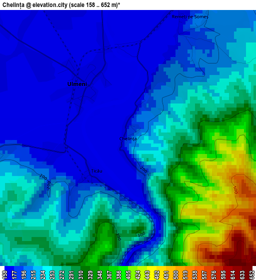
Below is the Elevation map of Chelința, which displays elevation range with different colors. Scale of the first map is from 158 to 652 m (518 to 2139 ft) with average elevation of 248.3 meters (=815 ft) [note 1]
These maps also provides idea of topography and contour of this city, they are displayed at different zoom levels. More info about maps, scale and edge coordinates you can find below images.
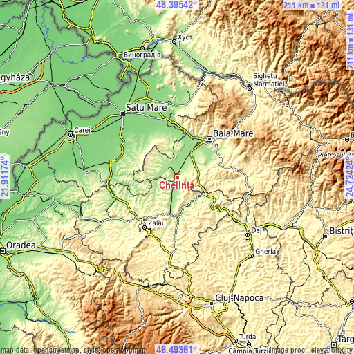
| \ | Map #1 | Topo.Map |
| Scale [m] | 158..652 m | × |
| Scale [ft] | 518..2139 ft | × |
| Average | 248.3 m = 815 ft | × |
| Width | 6.61 km = 4.1 mi | 211.5 km = 131.4 mi |
| Height | 6.61 km = 4.1 mi | 211.4 km = 131.4 mi |
| ↑Max Latitude | 47.482817° | 48.39542° |
| Latitude at center | 47.45311° | 47.45311° |
| ↓Min Latitude | 47.423386° | 46.49361° |
| ← Min Longitude | 23.274045° | 21.91174° |
| Longitude center | 23.31799° | 23.31799° |
| →Max Longitude | 23.361935° | 24.72424° |
Nearby cities:
Cities around Chelința sort by population:
• Ulmeni elevation 168 m
2 km,  318°
318°
• Mireşu Mare 166 m
5.3 km,  12°
12°
• Sălsig 160 m
9 km,  351°
351°
• Năpradea 190 m
9.6 km,  180°
180°
• Valea Chioarului 261 m
12.6 km,  100°
100°
• Benesat 175 m
5.2 km,  204°
204°
• Gârdani 159 m
10.9 km,  356°
356°
• Ariniş 166 m
8.2 km,  309°
309°
• Mânău 192 m
5.3 km, 307°
• Iadăra 225 m
6.7 km,  64°
64°
• Vălenii Șomcutei 240 m
10.3 km,  77°
77°
• Cehu Silvaniei 218 m
11.7 km,  246°
246°
Multilingual:
 En español:
Chelința elevación 184 m.
 En France:
Chelința élévation 184 m.
 Auf Deutsch:
Chelința höhe über dem Meeresspiegel ist 184 m.

Sources and notes:
- [note 1] Map square and city borders are not equal. Map elevation data is calculated only from area inside that square.
- [src 1] Elevation data from geonames database provided with same terms of usage.
- [src 2] The elevation map of Chelința is generated using elevation data from NASA's 3 arcsec (90m) resolution SRTM data.
- [src 3] Base (background) map © OpenStreetMap contributors tiles are generated by Geofabrik and OpenTopoMap.
Copyright & License:
This Chelința Elevation Map is licensed under CC BY-SA. You may reuse any part from this page, if you give a proper credit by linking to this URL:
 More info on terms of use page.