Ulmeni elevation
Ulmeni (Maramureş, Oraş Ulmeni), Romania elevation is 168 meters and Ulmeni elevation in feet is 551 ft above sea level [src 1]. Ulmeni is a seat of a second-order administrative division (feature code) with elevation that is 84 meters (276 ft) smaller than average city elevation in Romania.
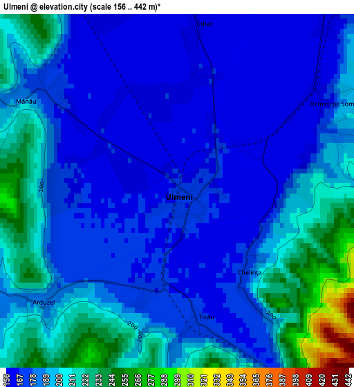
Below is the Elevation map of Ulmeni, which displays elevation range with different colors. Scale of the first map is from 156 to 442 m (512 to 1450 ft) with average elevation of 189.5 meters (=622 ft) [note 1]
These maps also provides idea of topography and contour of this city, they are displayed at different zoom levels. More info about maps, scale and edge coordinates you can find below images.
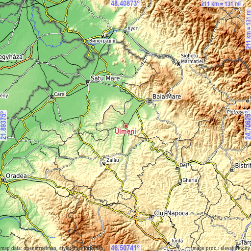
| \ | Map #1 | Map #2 | Topo.Map |
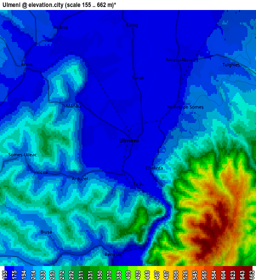
| Scale [m] | 156..442 m | 155..662 m | × |
| Scale [ft] | 512..1450 ft | 509..2172 ft | × |
| Average | 189.5 m = 622 ft | 239.4 m = 785 ft | × |
| Width | 6.61 km = 4.1 mi | 13.21 km = 8.2 mi | 211.4 km = 131.4 mi |
| Height | 6.61 km = 4.1 mi | 13.21 km = 8.2 mi | 211.4 km = 131.4 mi |
| ↑Max Latitude | 47.496369° | 47.526052° | 48.40873° |
| Latitude at center | 47.46667° | 47.46667° | 47.46667° |
| ↓Min Latitude | 47.436954° | 47.407221° | 46.50741° |
| ← Min Longitude | 23.256055° | 23.212109° | 21.89375° |
| Longitude center | 23.3° | 23.3° | 23.3° |
| →Max Longitude | 23.343945° | 23.387891° | 24.70625° |
Nearby cities:
Cities around Ulmeni sort by population:
• Mireşu Mare elevation 166 m
4.5 km,  34°
34°
• Sălsig 160 m
7.4 km,  0°
0°
• Năpradea 190 m
11.2 km,  173°
173°
• Benesat 175 m
6.3 km,  187°
187°
• Gârdani 159 m
9.4 km, 4°
• Băseşti 226 m
11.4 km,  279°
279°
• Chelința 184 m
2 km,  138°
138°
• Ariniş 166 m
6.2 km,  306°
306°
• Mânău 192 m
3.3 km,  300°
300°
• Iadăra 225 m
7.6 km,  79°
79°
• Vălenii Șomcutei 240 m
11.4 km,  86°
86°
• Cehu Silvaniei 218 m
11.2 km,  237°
237°
Multilingual:
 En español:
Ulmeni elevación 168 m.
 En France:
Ulmeni élévation 168 m.


Sources and notes:
- [note 1] Map square and city borders are not equal. Map elevation data is calculated only from area inside that square.
- [src 1] Elevation data from geonames database provided with same terms of usage.
- [src 2] The elevation map of Ulmeni is generated using elevation data from NASA's 3 arcsec (90m) resolution SRTM data.
- [src 3] Base (background) map © OpenStreetMap contributors tiles are generated by Geofabrik and OpenTopoMap.
Copyright & License:
This Ulmeni Elevation Map is licensed under CC BY-SA. You may reuse any part from this page, if you give a proper credit by linking to this URL:
 More info on terms of use page.