Chendrea elevation
Chendrea (Sălaj, Comuna Bălan), Romania elevation is 223 meters and Chendrea elevation in feet is 732 ft above sea level [src 1]. Chendrea is a populated place (feature code) with elevation that is 29 meters (95 ft) smaller than average city elevation in Romania.
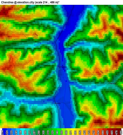
Below is the Elevation map of Chendrea, which displays elevation range with different colors. Scale of the first map is from 214 to 486 m (702 to 1594 ft) with average elevation of 323.2 meters (=1060 ft) [note 1]
These maps also provides idea of topography and contour of this city, they are displayed at different zoom levels. More info about maps, scale and edge coordinates you can find below images.
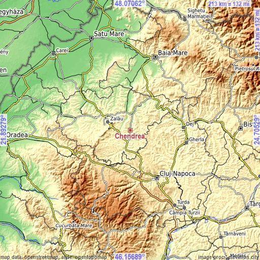
| \ | Map #1 | Topo.Map |
| Scale [m] | 214..486 m | × |
| Scale [ft] | 702..1594 ft | × |
| Average | 323.2 m = 1060 ft | × |
| Width | 6.65 km = 4.1 mi | 212.8 km = 132.2 mi |
| Height | 6.65 km = 4.1 mi | 212.8 km = 132.2 mi |
| ↑Max Latitude | 47.152254° | 48.07062° |
| Latitude at center | 47.12236° | 47.12236° |
| ↓Min Latitude | 47.09245° | 46.15689° |
| ← Min Longitude | 23.255095° | 21.89279° |
| Longitude center | 23.29904° | 23.29904° |
| →Max Longitude | 23.342985° | 24.70529° |
Nearby cities:
Cities around Chendrea sort by population:
• Bălan elevation 221 m
3.9 km,  14°
14°
• Hida 320 m
6.3 km,  190°
190°
• Creaca 209 m
9.4 km,  336°
336°
• Gâlgău Almaşului 271 m
9 km,  16°
16°
• Gârbou 354 m
10.6 km,  73°
73°
• Sânmihaiu Almaşului 314 m
11.8 km,  179°
179°
• Dragu 336 m
14 km,  146°
146°
• Cristolţ 352 m
13.3 km,  49°
49°
• Zimbor 303 m
13.8 km, 190°
• Tihău 198 m
11.9 km, 11°
• Treznea 339 m
14 km,  259°
259°
• Românaşi 250 m
9.1 km,  254°
254°
Multilingual:
 En español:
Chendrea elevación 223 m.
 En France:
Chendrea élévation 223 m.
 Auf Deutsch:
Chendrea höhe über dem Meeresspiegel ist 223 m.

Sources and notes:
- [note 1] Map square and city borders are not equal. Map elevation data is calculated only from area inside that square.
- [src 1] Elevation data from geonames database provided with same terms of usage.
- [src 2] The elevation map of Chendrea is generated using elevation data from NASA's 3 arcsec (90m) resolution SRTM data.
- [src 3] Base (background) map © OpenStreetMap contributors tiles are generated by Geofabrik and OpenTopoMap.
Copyright & License:
This Chendrea Elevation Map is licensed under CC BY-SA. You may reuse any part from this page, if you give a proper credit by linking to this URL:
 More info on terms of use page.