Cristolţ elevation
Cristolţ (Sălaj, Comuna Cristolţ), Romania elevation is 352 meters and Cristolţ elevation in feet is 1155 ft above sea level [src 1]. Cristolţ is a seat of a second-order administrative division (feature code) with elevation that is 100 meters (328 ft) bigger than average city elevation in Romania.
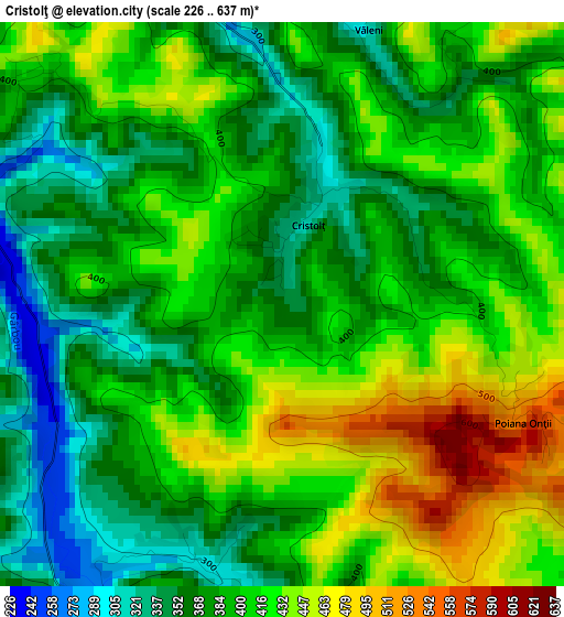
Below is the Elevation map of Cristolţ, which displays elevation range with different colors. Scale of the first map is from 226 to 637 m (741 to 2090 ft) with average elevation of 398.4 meters (=1307 ft) [note 1]
These maps also provides idea of topography and contour of this city, they are displayed at different zoom levels. More info about maps, scale and edge coordinates you can find below images.
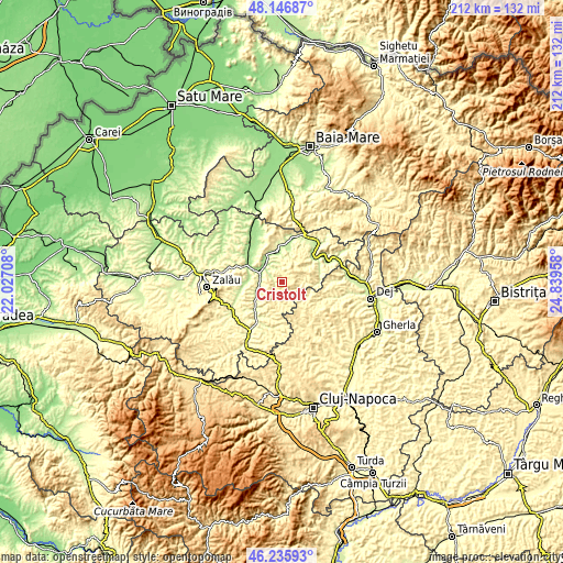
| \ | Map #1 | Topo.Map |
| Scale [m] | 226..637 m | × |
| Scale [ft] | 741..2090 ft | × |
| Average | 398.4 m = 1307 ft | × |
| Width | 6.64 km = 4.1 mi | 212.5 km = 132 mi |
| Height | 6.64 km = 4.1 mi | 212.5 km = 132 mi |
| ↑Max Latitude | 47.22985° | 48.14687° |
| Latitude at center | 47.2° | 47.2° |
| ↓Min Latitude | 47.170133° | 46.23593° |
| ← Min Longitude | 23.389385° | 22.02708° |
| Longitude center | 23.43333° | 23.43333° |
| →Max Longitude | 23.477275° | 24.83958° |
Nearby cities:
Cities around Cristolţ sort by population:
• Bălan elevation 221 m
10.4 km,  241°
241°
• Surduc 223 m
8.4 km,  311°
311°
• Creaca 209 m
13.8 km,  270°
270°
• Gâlgău Almaşului 271 m
7.6 km, 270°
• Gârbou 354 m
5.6 km,  180°
180°
• Letca 235 m
14.9 km,  4°
4°
• Băbeni 199 m
11.4 km,  347°
347°
• Lozna 206 m
13.2 km,  10°
10°
• Zalha 433 m
7.8 km,  103°
103°
• Tihău 198 m
8.4 km,  291°
291°
• Șimișna 250 m
14.8 km,  76°
76°
• Chendrea 223 m
13.3 km,  229°
229°
Multilingual:
 En español:
Cristolţ elevación 352 m.
 En France:
Cristolţ élévation 352 m.
 Auf Deutsch:
Cristolţ höhe über dem Meeresspiegel ist 352 m.

Sources and notes:
- [note 1] Map square and city borders are not equal. Map elevation data is calculated only from area inside that square.
- [src 1] Elevation data from geonames database provided with same terms of usage.
- [src 2] The elevation map of Cristolţ is generated using elevation data from NASA's 3 arcsec (90m) resolution SRTM data.
- [src 3] Base (background) map © OpenStreetMap contributors tiles are generated by Geofabrik and OpenTopoMap.
Copyright & License:
This Cristolţ Elevation Map is licensed under CC BY-SA. You may reuse any part from this page, if you give a proper credit by linking to this URL:
 More info on terms of use page.