Ciocârlia elevation
Ciocârlia (Ialomiţa, Comuna Ciocârlia), Romania elevation is 65 meters and Ciocârlia elevation in feet is 213 ft above sea level [src 1]. Ciocârlia is a seat of a second-order administrative division (feature code) with elevation that is 187 meters (614 ft) smaller than average city elevation in Romania.
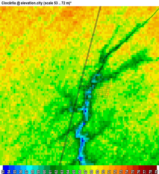
Below is the Elevation map of Ciocârlia, which displays elevation range with different colors. Scale of the first map is from 53 to 72 m (174 to 236 ft) with average elevation of 66.3 meters (=218 ft) [note 1]
These maps also provides idea of topography and contour of this city, they are displayed at different zoom levels. More info about maps, scale and edge coordinates you can find below images.
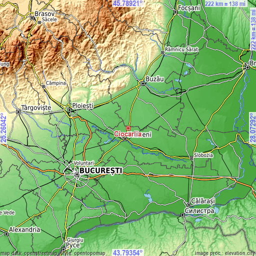
| \ | Map #1 | Topo.Map |
| Scale [m] | 53..72 m | × |
| Scale [ft] | 174..236 ft | × |
| Average | 66.3 m = 218 ft | × |
| Width | 6.93 km = 4.3 mi | 221.9 km = 137.9 mi |
| Height | 6.93 km = 4.3 mi | 221.9 km = 137.9 mi |
| ↑Max Latitude | 44.831174° | 45.78921° |
| Latitude at center | 44.8° | 44.8° |
| ↓Min Latitude | 44.768809° | 43.79354° |
| ← Min Longitude | 26.622725° | 25.26042° |
| Longitude center | 26.66667° | 26.66667° |
| →Max Longitude | 26.710615° | 28.07292° |
Nearby cities:
Cities around Ciocârlia sort by population:
• Urziceni elevation 52 m
9.6 km,  195°
195°
• Armăşeşti 60 m
8.6 km,  229°
229°
• Glodeanu-Sărat 65 m
7.5 km,  349°
349°
• Manasia 51 m
11.1 km,  180°
180°
• Glodeanu-Siliştea 74 m
11.2 km,  70°
70°
• Gârbovi 69 m
8.1 km,  103°
103°
• Bărbulești 51 m
9.8 km,  212°
212°
• Jilavele 59 m
11.2 km,  250°
250°
• Mihăileşti 70 m
13 km,  0°
0°
• Alexeni 50 m
13.2 km,  168°
168°
• Boldeşti 75 m
11.8 km,  308°
308°
• Malu Roșu 63 m
7.2 km, 252°
Multilingual:
 En español:
Ciocârlia elevación 65 m.
 En France:
Ciocârlia élévation 65 m.
 Auf Deutsch:
Ciocârlia höhe über dem Meeresspiegel ist 65 m.

Sources and notes:
- [note 1] Map square and city borders are not equal. Map elevation data is calculated only from area inside that square.
- [src 1] Elevation data from geonames database provided with same terms of usage.
- [src 2] The elevation map of Ciocârlia is generated using elevation data from NASA's 3 arcsec (90m) resolution SRTM data.
- [src 3] Base (background) map © OpenStreetMap contributors tiles are generated by Geofabrik and OpenTopoMap.
Copyright & License:
This Ciocârlia Elevation Map is licensed under CC BY-SA. You may reuse any part from this page, if you give a proper credit by linking to this URL:
 More info on terms of use page.