Cireșoaia elevation
Cireșoaia (Bacău, Oraş Slãnic-Moldova), Romania elevation is 336 meters and Cireșoaia elevation in feet is 1102 ft above sea level [src 1]. Cireșoaia is a populated place (feature code) with elevation that is 84 meters (276 ft) bigger than average city elevation in Romania.
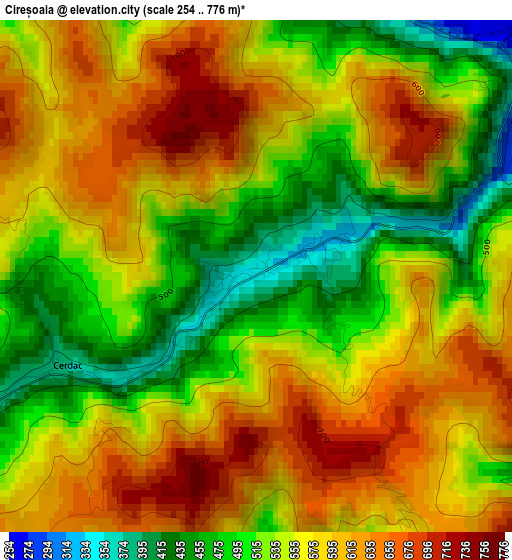
Below is the Elevation map of Cireșoaia, which displays elevation range with different colors. Scale of the first map is from 254 to 776 m (833 to 2546 ft) with average elevation of 559.8 meters (=1837 ft) [note 1]
These maps also provides idea of topography and contour of this city, they are displayed at different zoom levels. More info about maps, scale and edge coordinates you can find below images.
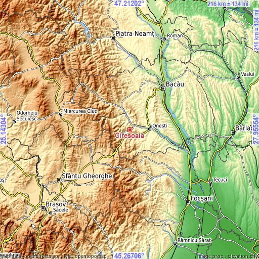
| \ | Map #1 | Topo.Map |
| Scale [m] | 254..776 m | × |
| Scale [ft] | 833..2546 ft | × |
| Average | 559.8 m = 1837 ft | × |
| Width | 6.76 km = 4.2 mi | 216.3 km = 134.4 mi |
| Height | 6.76 km = 4.2 mi | 216.2 km = 134.3 mi |
| ↑Max Latitude | 46.278541° | 47.21202° |
| Latitude at center | 46.24816° | 46.24816° |
| ↓Min Latitude | 46.217762° | 45.26706° |
| ← Min Longitude | 26.505345° | 25.14304° |
| Longitude center | 26.54929° | 26.54929° |
| →Max Longitude | 26.593235° | 27.95554° |
Nearby cities:
Cities around Cireșoaia sort by population:
• Târgu Ocna elevation 261 m
6 km,  55°
55°
• Dofteana 333 m
8 km,  341°
341°
• Oituz 306 m
7.5 km,  135°
135°
• Slănic-Moldova 422 m
6.4 km,  244°
244°
• Pârgăreşti 330 m
7.7 km,  88°
88°
• Cucuieți 325 m
8.8 km,  2°
2°
• Satu Nou 351 m
8 km, 92°
• Cerdac 384 m
2.8 km,  245°
245°
• Hăghiac 334 m
7.5 km, 341°
• Vâlcele 327 m
6.8 km,  35°
35°
• Ștefan Vodă 341 m
8.2 km, 339°
• Ferestrău-Oituz 308 m
5.5 km,  157°
157°
Multilingual:
 En español:
Cireșoaia elevación 336 m.
 En France:
Cireșoaia élévation 336 m.
 Auf Deutsch:
Cireșoaia höhe über dem Meeresspiegel ist 336 m.

Sources and notes:
- [note 1] Map square and city borders are not equal. Map elevation data is calculated only from area inside that square.
- [src 1] Elevation data from geonames database provided with same terms of usage.
- [src 2] The elevation map of Cireșoaia is generated using elevation data from NASA's 3 arcsec (90m) resolution SRTM data.
- [src 3] Base (background) map © OpenStreetMap contributors tiles are generated by Geofabrik and OpenTopoMap.
Copyright & License:
This Cireșoaia Elevation Map is licensed under CC BY-SA. You may reuse any part from this page, if you give a proper credit by linking to this URL:
 More info on terms of use page.