Oituz elevation
Oituz (Bacău, Comuna Oituz), Romania elevation is 306 meters and Oituz elevation in feet is 1004 ft above sea level [src 1]. Oituz is a seat of a second-order administrative division (feature code) with elevation that is 54 meters (177 ft) bigger than average city elevation in Romania.
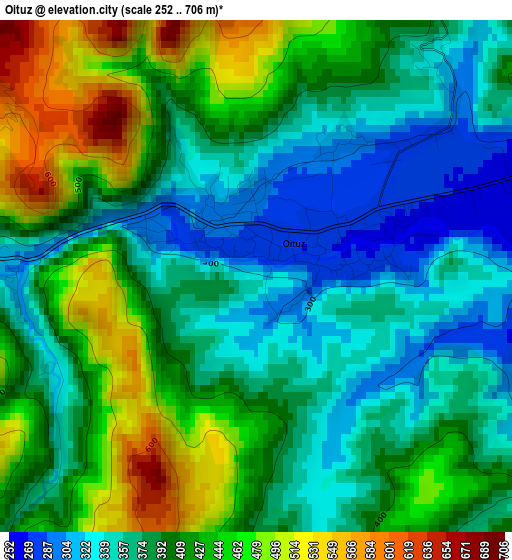
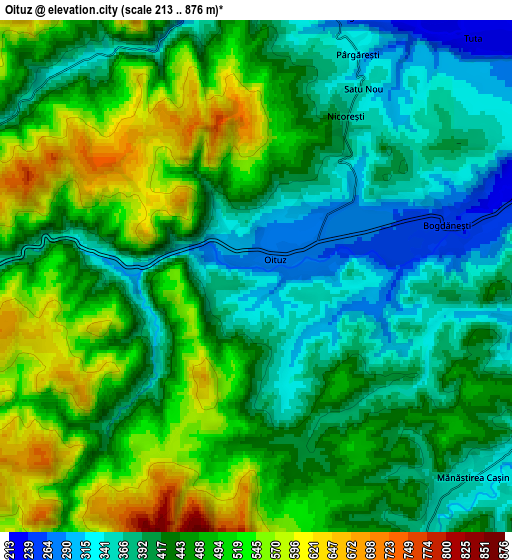
Below is the Elevation map of Oituz, which displays elevation range with different colors. Scale of the first map is from 252 to 706 m (827 to 2316 ft) with average elevation of 401.1 meters (=1316 ft) [note 1]
These maps also provides idea of topography and contour of this city, they are displayed at different zoom levels. More info about maps, scale and edge coordinates you can find below images.
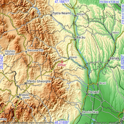
| \ | Map #1 | Map #2 | Topo.Map |
| Scale [m] | 252..706 m | 213..876 m | × |
| Scale [ft] | 827..2316 ft | 699..2874 ft | × |
| Average | 401.1 m = 1316 ft | 447.7 m = 1469 ft | × |
| Width | 6.76 km = 4.2 mi | 13.53 km = 8.4 mi | 216.4 km = 134.5 mi |
| Height | 6.76 km = 4.2 mi | 13.53 km = 8.4 mi | 216.4 km = 134.5 mi |
| ↑Max Latitude | 46.230408° | 46.260799° | 47.16471° |
| Latitude at center | 46.2° | 46.2° | 46.2° |
| ↓Min Latitude | 46.169575° | 46.139133° | 45.21805° |
| ← Min Longitude | 26.572725° | 26.528779° | 25.21042° |
| Longitude center | 26.61667° | 26.61667° | 26.61667° |
| →Max Longitude | 26.660615° | 26.704561° | 28.02292° |
Nearby cities:
Cities around Oituz sort by population:
• Târgu Ocna elevation 261 m
8.8 km,  358°
358°
• Târgu Trotuş 242 m
8.4 km,  27°
27°
• Pârgăreşti 330 m
6.1 km,  24°
24°
• Caşin 245 m
10.3 km,  90°
90°
• Bogdăneşti 270 m
5.5 km,  70°
70°
• Tuta 232 m
8.5 km,  42°
42°
• Cireșoaia 336 m
7.5 km,  315°
315°
• Satu Nou 351 m
5.7 km, 29°
• Cerdac 384 m
8.8 km,  298°
298°
• Viișoara 258 m
9.9 km, 20°
• Ferestrău-Oituz 308 m
3.1 km,  275°
275°
• Mânăstirea Caşin 352 m
7.6 km,  137°
137°
Multilingual:
 En español:
Oituz elevación 306 m.
 En France:
Oituz élévation 306 m.


Sources and notes:
- [note 1] Map square and city borders are not equal. Map elevation data is calculated only from area inside that square.
- [src 1] Elevation data from geonames database provided with same terms of usage.
- [src 2] The elevation map of Oituz is generated using elevation data from NASA's 3 arcsec (90m) resolution SRTM data.
- [src 3] Base (background) map © OpenStreetMap contributors tiles are generated by Geofabrik and OpenTopoMap.
Copyright & License:
This Oituz Elevation Map is licensed under CC BY-SA. You may reuse any part from this page, if you give a proper credit by linking to this URL:
 More info on terms of use page.