Cârlibaba elevation
Cârlibaba (Suceava, Comuna Cârlibaba), Romania elevation is 1134 meters and Cârlibaba elevation in feet is 3720 ft above sea level [src 1]. Cârlibaba is a seat of a second-order administrative division (feature code) with elevation that is 882 meters (2894 ft) bigger than average city elevation in Romania.
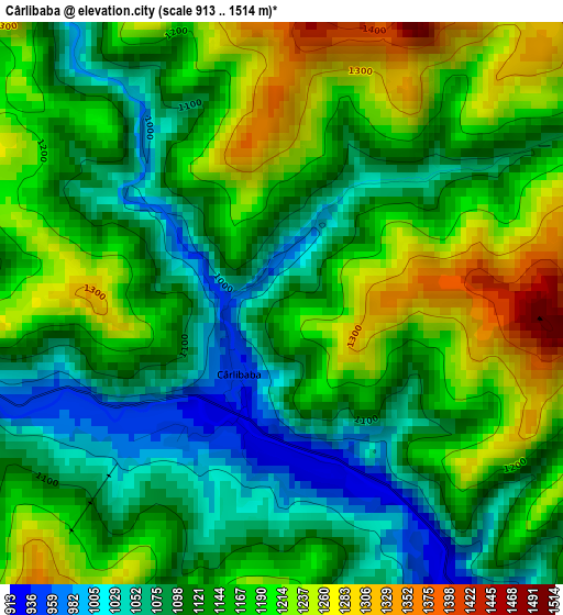
Below is the Elevation map of Cârlibaba, which displays elevation range with different colors. Scale of the first map is from 913 to 1514 m (2995 to 4967 ft) with average elevation of 1148.9 meters (=3769 ft) [note 1]
These maps also provides idea of topography and contour of this city, they are displayed at different zoom levels. More info about maps, scale and edge coordinates you can find below images.
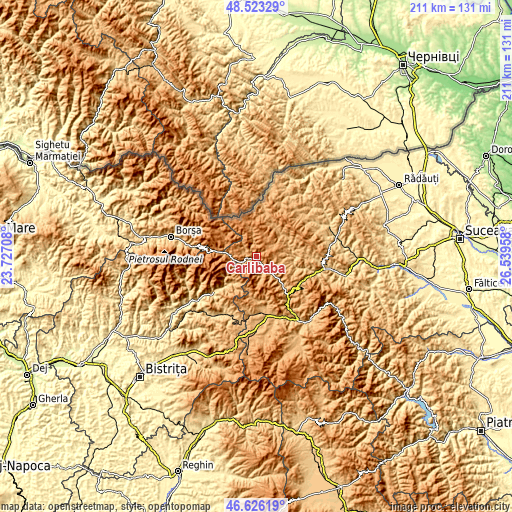
| \ | Map #1 | Topo.Map |
| Scale [m] | 913..1514 m | × |
| Scale [ft] | 2995..4967 ft | × |
| Average | 1148.9 m = 3769 ft | × |
| Width | 6.59 km = 4.1 mi | 210.9 km = 131 mi |
| Height | 6.59 km = 4.1 mi | 210.9 km = 131 mi |
| ↑Max Latitude | 47.612963° | 48.52329° |
| Latitude at center | 47.58333° | 47.58333° |
| ↓Min Latitude | 47.55368° | 46.62619° |
| ← Min Longitude | 25.089385° | 23.72708° |
| Longitude center | 25.13333° | 25.13333° |
| →Max Longitude | 25.177275° | 26.53958° |
Nearby cities:
Cities around Cârlibaba sort by population:
• Dorna Cândrenilor elevation 839 m
27.4 km,  161°
161°
• Fundu Moldovei 850 m
20.8 km,  105°
105°
• Iacobeni 1117 m
21.6 km,  140°
140°
• Lunca Ilvei 751 m
26.6 km,  205°
205°
• Pojorâta 724 m
24.9 km, 107°
• Șanț 644 m
23 km,  229°
229°
• Izvoarele Sucevei 956 m
18.9 km,  11°
11°
• Moldova Suliţa 961 m
14.1 km,  38°
38°
• Breaza 850 m
14.3 km,  75°
75°
• Ciocănești 853 m
15.8 km, 136°
• Colacu 757 m
18.6 km, 105°
• Coșna 856 m
23.9 km,  171°
171°
Multilingual:
 En español:
Cârlibaba elevación 1134 m.
 En France:
Cârlibaba élévation 1134 m.
 Auf Deutsch:
Cârlibaba höhe über dem Meeresspiegel ist 1134 m.

Sources and notes:
- [note 1] Map square and city borders are not equal. Map elevation data is calculated only from area inside that square.
- [src 1] Elevation data from geonames database provided with same terms of usage.
- [src 2] The elevation map of Cârlibaba is generated using elevation data from NASA's 3 arcsec (90m) resolution SRTM data.
- [src 3] Base (background) map © OpenStreetMap contributors tiles are generated by Geofabrik and OpenTopoMap.
Copyright & License:
This Cârlibaba Elevation Map is licensed under CC BY-SA. You may reuse any part from this page, if you give a proper credit by linking to this URL:
 More info on terms of use page.