Comanca elevation
Comanca (Olt, Comuna Deveselu), Romania elevation is 116 meters and Comanca elevation in feet is 381 ft above sea level [src 1]. Comanca is a populated place (feature code) with elevation that is 136 meters (446 ft) smaller than average city elevation in Romania.
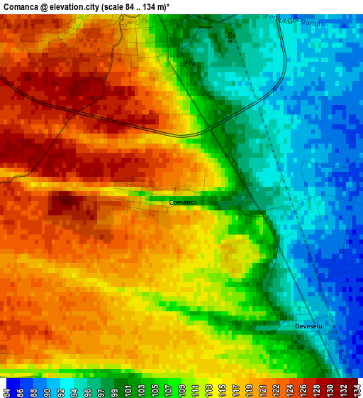
Below is the Elevation map of Comanca, which displays elevation range with different colors. Scale of the first map is from 84 to 134 m (276 to 440 ft) with average elevation of 109.8 meters (=360 ft) [note 1]
These maps also provides idea of topography and contour of this city, they are displayed at different zoom levels. More info about maps, scale and edge coordinates you can find below images.
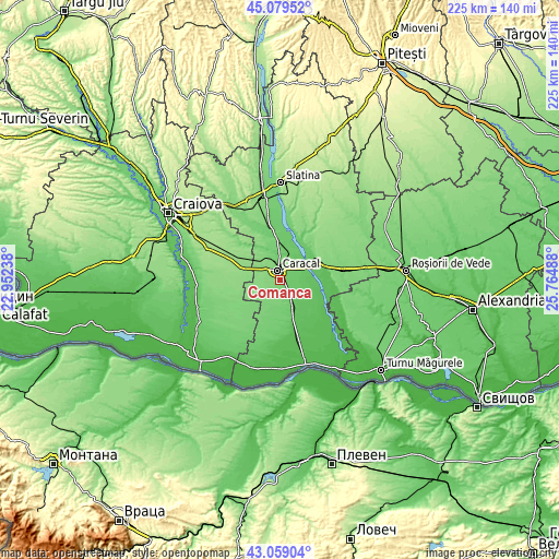
| \ | Map #1 | Topo.Map |
| Scale [m] | 84..134 m | × |
| Scale [ft] | 276..440 ft | × |
| Average | 109.8 m = 360 ft | × |
| Width | 7.02 km = 4.4 mi | 224.7 km = 139.6 mi |
| Height | 7.02 km = 4.4 mi | 224.6 km = 139.6 mi |
| ↑Max Latitude | 44.109462° | 45.07952° |
| Latitude at center | 44.0779° | 44.0779° |
| ↓Min Latitude | 44.046321° | 43.05904° |
| ← Min Longitude | 24.314685° | 22.95238° |
| Longitude center | 24.35863° | 24.35863° |
| →Max Longitude | 24.402575° | 25.76488° |
Nearby cities:
Cities around Comanca sort by population:
• Caracal elevation 105 m
4.4 km,  350°
350°
• Fărcaşele 88 m
10 km,  36°
36°
• Dobrosloveni 100 m
11.7 km,  3°
3°
• Traian 79 m
10 km,  132°
132°
• Deveselu 93 m
2.3 km,  122°
122°
• Redea 124 m
5.6 km,  236°
236°
• Rotunda 111 m
11 km,  197°
197°
• Stoeneşti 74 m
12.1 km,  69°
69°
• Vlădila 93 m
9.3 km,  159°
159°
• Drăghiceni 135 m
10.6 km,  305°
305°
• Fărcașu de Jos 80 m
10.3 km,  51°
51°
• Ghimpați 88 m
10 km,  32°
32°
Multilingual:
 En español:
Comanca elevación 116 m.
 En France:
Comanca élévation 116 m.


Sources and notes:
- [note 1] Map square and city borders are not equal. Map elevation data is calculated only from area inside that square.
- [src 1] Elevation data from geonames database provided with same terms of usage.
- [src 2] The elevation map of Comanca is generated using elevation data from NASA's 3 arcsec (90m) resolution SRTM data.
- [src 3] Base (background) map © OpenStreetMap contributors tiles are generated by Geofabrik and OpenTopoMap.
Copyright & License:
This Comanca Elevation Map is licensed under CC BY-SA. You may reuse any part from this page, if you give a proper credit by linking to this URL:
 More info on terms of use page.