Drăghiceni elevation
Drăghiceni (Olt, Comuna Drăghiceni), Romania elevation is 135 meters and Drăghiceni elevation in feet is 443 ft above sea level [src 1]. Drăghiceni is a seat of a second-order administrative division (feature code) with elevation that is 117 meters (384 ft) smaller than average city elevation in Romania.
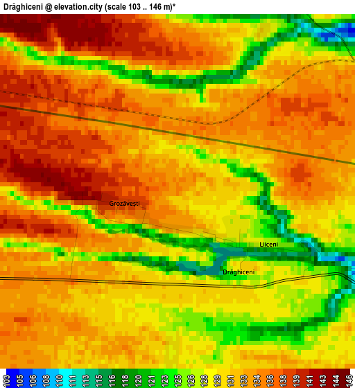
Below is the Elevation map of Drăghiceni, which displays elevation range with different colors. Scale of the first map is from 103 to 146 m (338 to 479 ft) with average elevation of 131.4 meters (=431 ft) [note 1]
These maps also provides idea of topography and contour of this city, they are displayed at different zoom levels. More info about maps, scale and edge coordinates you can find below images.
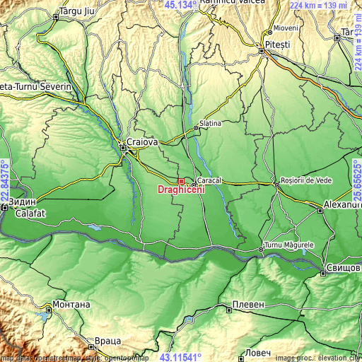
| \ | Map #1 | Topo.Map |
| Scale [m] | 103..146 m | × |
| Scale [ft] | 338..479 ft | × |
| Average | 131.4 m = 431 ft | × |
| Width | 7.01 km = 4.4 mi | 224.4 km = 139.4 mi |
| Height | 7.01 km = 4.4 mi | 224.4 km = 139.4 mi |
| ↑Max Latitude | 44.164862° | 45.134° |
| Latitude at center | 44.13333° | 44.13333° |
| ↓Min Latitude | 44.101781° | 43.11541° |
| ← Min Longitude | 24.206055° | 22.84375° |
| Longitude center | 24.25° | 24.25° |
| →Max Longitude | 24.293945° | 25.65625° |
Nearby cities:
Cities around Drăghiceni sort by population:
• Caracal elevation 105 m
8.2 km,  103°
103°
• Celaru 136 m
13.1 km,  225°
225°
• Dobrosloveni 100 m
10.8 km,  59°
59°
• Dioşti 138 m
5.6 km,  250°
250°
• Deveselu 93 m
13 km,  124°
124°
• Redea 124 m
10.1 km,  156°
156°
• Cezieni 115 m
5.7 km,  13°
13°
• Comanca 116 m
10.6 km,  125°
125°
• Zănoaga 152 m
12.3 km,  281°
281°
• Osica de Jos 99 m
12.6 km, 10°
• Radomir 145 m
6.7 km,  258°
258°
• Teslui 119 m
11.1 km,  316°
316°
Multilingual:
 En español:
Drăghiceni elevación 135 m.
 En France:
Drăghiceni élévation 135 m.
 Auf Deutsch:
Drăghiceni höhe über dem Meeresspiegel ist 135 m.

Sources and notes:
- [note 1] Map square and city borders are not equal. Map elevation data is calculated only from area inside that square.
- [src 1] Elevation data from geonames database provided with same terms of usage.
- [src 2] The elevation map of Drăghiceni is generated using elevation data from NASA's 3 arcsec (90m) resolution SRTM data.
- [src 3] Base (background) map © OpenStreetMap contributors tiles are generated by Geofabrik and OpenTopoMap.
Copyright & License:
This Drăghiceni Elevation Map is licensed under CC BY-SA. You may reuse any part from this page, if you give a proper credit by linking to this URL:
 More info on terms of use page.