Comarnic elevation
Comarnic (Prahova, Oraş Comarnic), Romania elevation is 641 meters and Comarnic elevation in feet is 2103 ft above sea level [src 1]. Comarnic is a seat of a second-order administrative division (feature code) with elevation that is 389 meters (1276 ft) bigger than average city elevation in Romania.
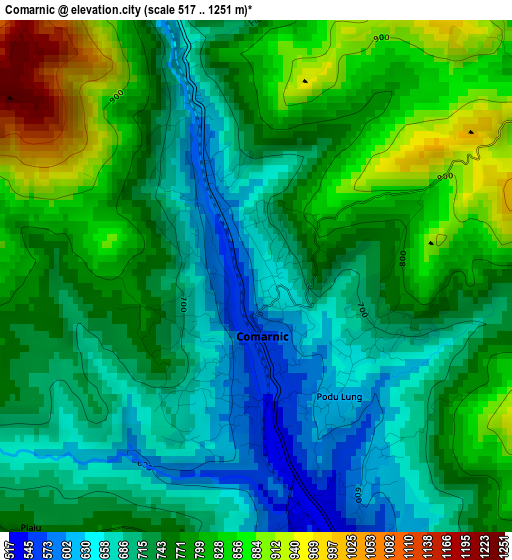
Below is the Elevation map of Comarnic, which displays elevation range with different colors. Scale of the first map is from 517 to 1251 m (1696 to 4104 ft) with average elevation of 755.5 meters (=2479 ft) [note 1]
These maps also provides idea of topography and contour of this city, they are displayed at different zoom levels. More info about maps, scale and edge coordinates you can find below images.
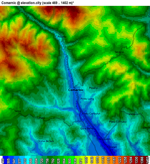
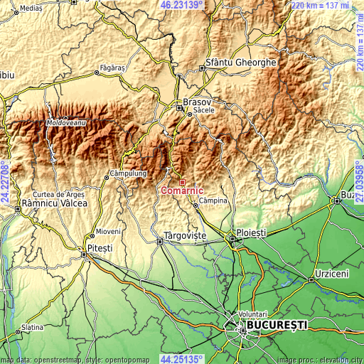
| \ | Map #1 | Map #2 | Topo.Map |
| Scale [m] | 517..1251 m | 469..1402 m | × |
| Scale [ft] | 1696..4104 ft | 1539..4600 ft | × |
| Average | 755.5 m = 2479 ft | 820.8 m = 2693 ft | × |
| Width | 6.88 km = 4.3 mi | 13.76 km = 8.6 mi | 220.2 km = 136.8 mi |
| Height | 6.88 km = 4.3 mi | 13.76 km = 8.6 mi | 220.1 km = 136.8 mi |
| ↑Max Latitude | 45.28093° | 45.311843° | 46.23139° |
| Latitude at center | 45.25° | 45.25° | 45.25° |
| ↓Min Latitude | 45.219053° | 45.18809° | 44.25135° |
| ← Min Longitude | 25.589385° | 25.545439° | 24.22708° |
| Longitude center | 25.63333° | 25.63333° | 25.63333° |
| →Max Longitude | 25.677275° | 25.721221° | 27.03958° |
Nearby cities:
Cities around Comarnic sort by population:
• Breaza elevation 548 m
7.9 km,  160°
160°
• Breaza de Sus 571 m
6 km, 162°
• Teșila 688 m
9.2 km,  49°
49°
• Poiana 746 m
2.4 km,  102°
102°
• Şotrile 731 m
7.5 km,  119°
119°
• Ghioșești 630 m
1 km,  211°
211°
• Posada 749 m
4.3 km,  344°
344°
• Secăria 926 m
5.4 km, 46°
• Ocina de Sus 660 m
6.1 km, 206°
• Valea Târsei 493 m
8.1 km,  180°
180°
• Talea 824 m
6 km,  243°
243°
• Gura Beliei 538 m
4.6 km, 163°
Multilingual:
 En español:
Comarnic elevación 641 m.
 En France:
Comarnic élévation 641 m.
 Auf Deutsch:
Comarnic höhe über dem Meeresspiegel ist 641 m.

Sources and notes:
- [note 1] Map square and city borders are not equal. Map elevation data is calculated only from area inside that square.
- [src 1] Elevation data from geonames database provided with same terms of usage.
- [src 2] The elevation map of Comarnic is generated using elevation data from NASA's 3 arcsec (90m) resolution SRTM data.
- [src 3] Base (background) map © OpenStreetMap contributors tiles are generated by Geofabrik and OpenTopoMap.
Copyright & License:
This Comarnic Elevation Map is licensed under CC BY-SA. You may reuse any part from this page, if you give a proper credit by linking to this URL:
 More info on terms of use page.