Corund elevation
Corund (Harghita, Comuna Corund), Romania elevation is 589 meters and Corund elevation in feet is 1932 ft above sea level [src 1]. Corund is a seat of a second-order administrative division (feature code) with elevation that is 337 meters (1106 ft) bigger than average city elevation in Romania.
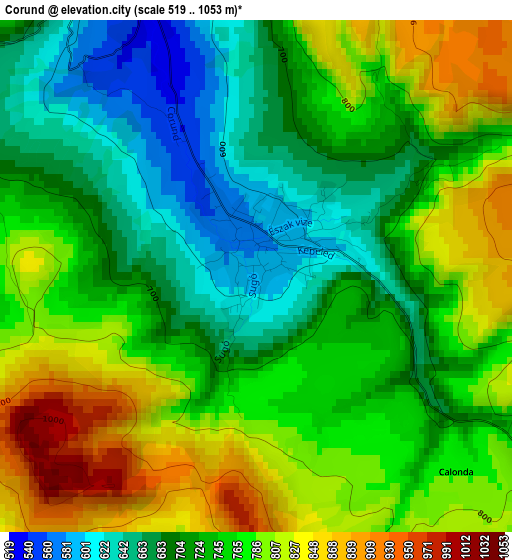
Below is the Elevation map of Corund, which displays elevation range with different colors. Scale of the first map is from 519 to 1053 m (1703 to 3455 ft) with average elevation of 747.9 meters (=2454 ft) [note 1]
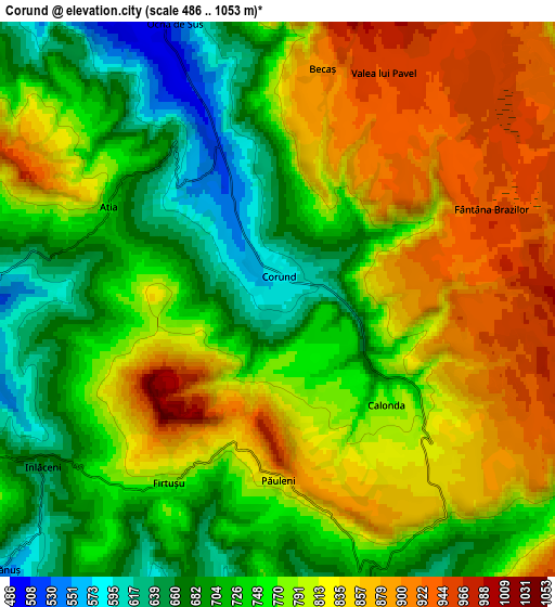
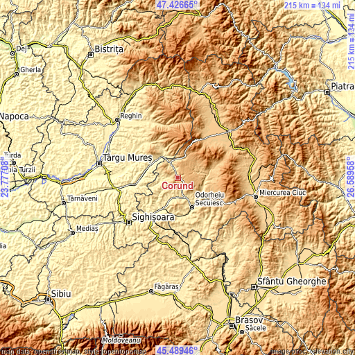
These maps also provides idea of topography and contour of this city, they are displayed at different zoom levels. More info about maps, scale and edge coordinates you can find below images.
| \ | Map #1 | Map #2 | Topo.Map |
| Scale [m] | 519..1053 m | 486..1053 m | × |
| Scale [ft] | 1703..3455 ft | 1594..3455 ft | × |
| Average | 747.9 m = 2454 ft | 777.2 m = 2550 ft | × |
| Width | 6.73 km = 4.2 mi | 13.46 km = 8.4 mi | 215.4 km = 133.8 mi |
| Height | 6.73 km = 4.2 mi | 13.46 km = 8.4 mi | 215.4 km = 133.8 mi |
| ↑Max Latitude | 46.49693° | 46.527173° | 47.42665° |
| Latitude at center | 46.46667° | 46.46667° | 46.46667° |
| ↓Min Latitude | 46.436393° | 46.406099° | 45.48946° |
| ← Min Longitude | 25.139385° | 25.095439° | 23.77708° |
| Longitude center | 25.18333° | 25.18333° | 25.18333° |
| →Max Longitude | 25.227275° | 25.271221° | 26.58958° |
Nearby cities:
Cities around Corund sort by population:
• Sovata elevation 454 m
15.7 km,  325°
325°
• Praid 527 m
10 km,  337°
337°
• Zetea 526 m
16.8 km,  123°
123°
• Lupeni 598 m
9.6 km,  164°
164°
• Dealu 832 m
11.6 km,  129°
129°
• Simoneşti 440 m
16.1 km,  203°
203°
• Atid 442 m
10.4 km,  259°
259°
• Ocna de Jos 495 m
7.8 km, 328°
• Sărățeni 410 m
16.8 km,  309°
309°
• Vărşag 818 m
13.9 km,  66°
66°
• Ocna de Sus 532 m
7.2 km, 340°
• Sâncrai 587 m
15.1 km,  137°
137°
Multilingual:
 En español:
Corund elevación 589 m.
 En France:
Corund élévation 589 m.


Sources and notes:
- [note 1] Map square and city borders are not equal. Map elevation data is calculated only from area inside that square.
- [src 1] Elevation data from geonames database provided with same terms of usage.
- [src 2] The elevation map of Corund is generated using elevation data from NASA's 3 arcsec (90m) resolution SRTM data.
- [src 3] Base (background) map © OpenStreetMap contributors tiles are generated by Geofabrik and OpenTopoMap.
Copyright & License:
This Corund Elevation Map is licensed under CC BY-SA. You may reuse any part from this page, if you give a proper credit by linking to this URL:
 More info on terms of use page.