Sovata elevation
Sovata (Mureş, Oraş Sovata), Romania elevation is 454 meters and Sovata elevation in feet is 1490 ft above sea level [src 1]. Sovata is a seat of a second-order administrative division (feature code) with elevation that is 202 meters (663 ft) bigger than average city elevation in Romania.
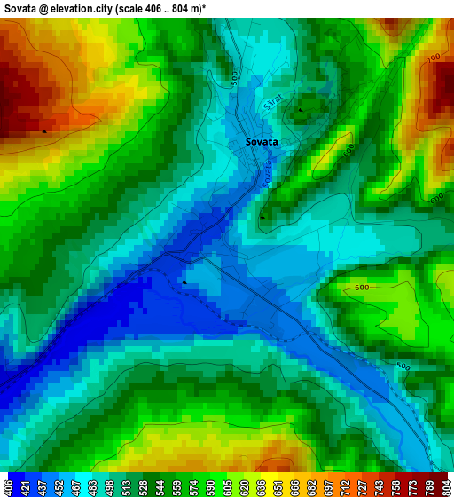
Below is the Elevation map of Sovata, which displays elevation range with different colors. Scale of the first map is from 406 to 804 m (1332 to 2638 ft) with average elevation of 541.4 meters (=1776 ft) [note 1]
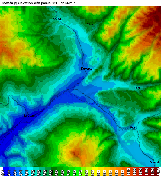
These maps also provides idea of topography and contour of this city, they are displayed at different zoom levels. More info about maps, scale and edge coordinates you can find below images.
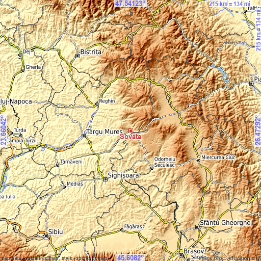
| \ | Map #1 | Map #2 | Topo.Map |
| Scale [m] | 406..804 m | 381..1164 m | × |
| Scale [ft] | 1332..2638 ft | 1250..3819 ft | × |
| Average | 541.4 m = 1776 ft | 648.9 m = 2129 ft | × |
| Width | 6.72 km = 4.2 mi | 13.43 km = 8.3 mi | 214.9 km = 133.5 mi |
| Height | 6.72 km = 4.2 mi | 13.43 km = 8.3 mi | 214.9 km = 133.5 mi |
| ↑Max Latitude | 46.613525° | 46.643703° | 47.54123° |
| Latitude at center | 46.58333° | 46.58333° | 46.58333° |
| ↓Min Latitude | 46.553118° | 46.522889° | 45.6082° |
| ← Min Longitude | 25.022725° | 24.978779° | 23.66042° |
| Longitude center | 25.06667° | 25.06667° | 25.06667° |
| →Max Longitude | 25.110615° | 25.154561° | 26.47292° |
Nearby cities:
Cities around Sovata sort by population:
• Praid elevation 527 m
6.3 km,  126°
126°
• Corund 589 m
15.7 km,  145°
145°
• Ghindari 389 m
14.7 km,  231°
231°
• Eremitu 541 m
13.8 km,  312°
312°
• Atid 442 m
14.9 km,  184°
184°
• Măgherani 393 m
12.9 km,  261°
261°
• Chibed 384 m
9.7 km,  235°
235°
• Ocna de Jos 495 m
7.9 km,  142°
142°
• Sărățeni 410 m
4.7 km, 240°
• Ocna de Sus 532 m
9 km, 133°
• Trei Sate 364 m
17.6 km, 227°
• Bereni 366 m
15.4 km, 259°
Multilingual:
 En español:
Sovata elevación 454 m.
 En France:
Sovata élévation 454 m.


Sources and notes:
- [note 1] Map square and city borders are not equal. Map elevation data is calculated only from area inside that square.
- [src 1] Elevation data from geonames database provided with same terms of usage.
- [src 2] The elevation map of Sovata is generated using elevation data from NASA's 3 arcsec (90m) resolution SRTM data.
- [src 3] Base (background) map © OpenStreetMap contributors tiles are generated by Geofabrik and OpenTopoMap.
Copyright & License:
This Sovata Elevation Map is licensed under CC BY-SA. You may reuse any part from this page, if you give a proper credit by linking to this URL:
 More info on terms of use page.