Craiova elevation
Craiova (Dolj, Municipiul Craiova), Romania elevation is 105 meters and Craiova elevation in feet is 344 ft above sea level [src 1]. Craiova is a seat of a first-order administrative division (feature code) with elevation that is 147 meters (482 ft) smaller than average city elevation in Romania.
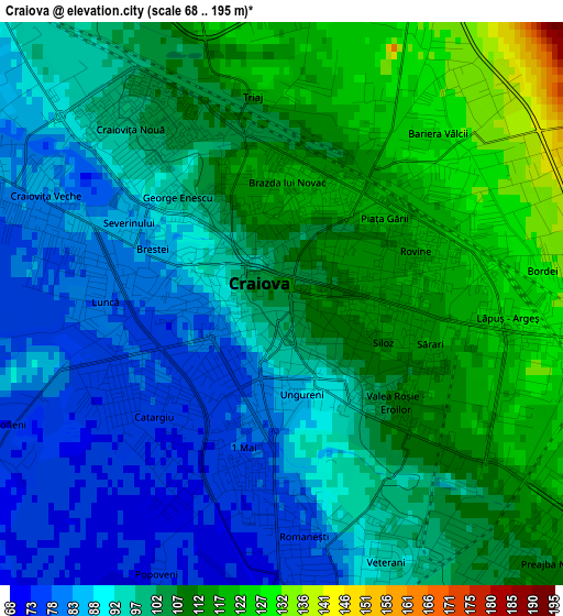
Below is the Elevation map of Craiova, which displays elevation range with different colors. Scale of the first map is from 68 to 195 m (223 to 640 ft) with average elevation of 100.3 meters (=329 ft) [note 1]
These maps also provides idea of topography and contour of this city, they are displayed at different zoom levels. More info about maps, scale and edge coordinates you can find below images.
| \ | Map #1 | Map #2 | Topo.Map |
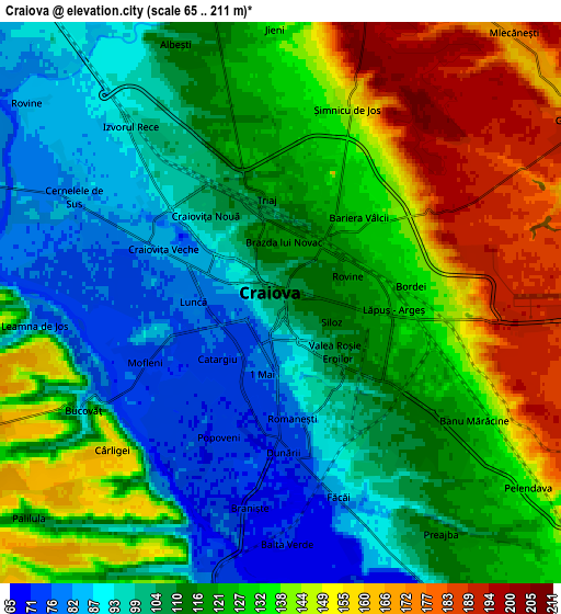
| Scale [m] | 68..195 m | 65..211 m | × |
| Scale [ft] | 223..640 ft | 213..692 ft | × |
| Average | 100.3 m = 329 ft | 120.2 m = 394 ft | × |
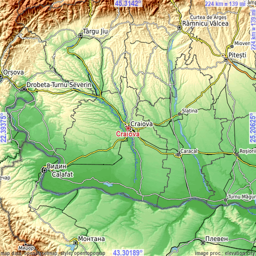
| Width | 6.99 km = 4.3 mi | 13.98 km = 8.7 mi | 223.7 km = 139 mi |
| Height | 6.99 km = 4.3 mi | 13.98 km = 8.7 mi | 223.7 km = 139 mi |
| ↑Max Latitude | 44.348104° | 44.379521° | 45.3142° |
| Latitude at center | 44.31667° | 44.31667° | 44.31667° |
| ↓Min Latitude | 44.285219° | 44.253751° | 43.30189° |
| ← Min Longitude | 23.756055° | 23.712109° | 22.39375° |
| Longitude center | 23.8° | 23.8° | 23.8° |
| →Max Longitude | 23.843945° | 23.887891° | 25.20625° |
Nearby cities:
Cities around Craiova sort by population:
• Podari elevation 73 m
7.5 km,  190°
190°
• Malu Mare 89 m
9.3 km,  153°
153°
• Şimnicu de Sus 154 m
7.4 km,  0°
0°
• Bucovăţ 72 m
4.4 km,  245°
245°
• Breasta 125 m
9.5 km,  281°
281°
• Cernele 81 m
5 km,  292°
292°
• Mischii 190 m
8.4 km,  28°
28°
• Mofleni 76 m
3.7 km,  244°
244°
• Făcăi 88 m
5.1 km,  161°
161°
• Popoveni 73 m
3.5 km,  204°
204°
• Preajba 116 m
7 km, 145°
• Cârcea 181 m
9.6 km,  123°
123°
Multilingual:
 En español:
Craiova elevación 105 m.
 En France:
Craiova élévation 105 m.


Sources and notes:
- [note 1] Map square and city borders are not equal. Map elevation data is calculated only from area inside that square.
- [src 1] Elevation data from geonames database provided with same terms of usage.
- [src 2] The elevation map of Craiova is generated using elevation data from NASA's 3 arcsec (90m) resolution SRTM data.
- [src 3] Base (background) map © OpenStreetMap contributors tiles are generated by Geofabrik and OpenTopoMap.
Copyright & License:
This Craiova Elevation Map is licensed under CC BY-SA. You may reuse any part from this page, if you give a proper credit by linking to this URL:
 More info on terms of use page.