Preajba elevation
Preajba (Dolj, Comuna Malu Mare), Romania elevation is 116 meters and Preajba elevation in feet is 381 ft above sea level [src 1]. Preajba is a populated place (feature code) with elevation that is 136 meters (446 ft) smaller than average city elevation in Romania.
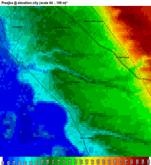
Below is the Elevation map of Preajba, which displays elevation range with different colors. Scale of the first map is from 64 to 199 m (210 to 653 ft) with average elevation of 107.4 meters (=352 ft) [note 1]
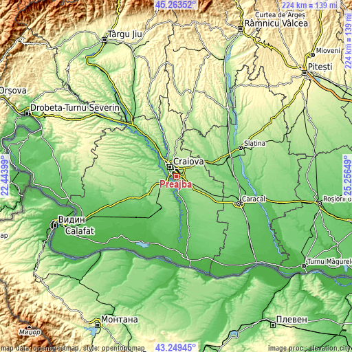
These maps also provides idea of topography and contour of this city, they are displayed at different zoom levels. More info about maps, scale and edge coordinates you can find below images.
| \ | Map #1 | Topo.Map |
| Scale [m] | 64..199 m | × |
| Scale [ft] | 210..653 ft | × |
| Average | 107.4 m = 352 ft | × |
| Width | 7 km = 4.3 mi | 223.9 km = 139.1 mi |
| Height | 7 km = 4.3 mi | 223.9 km = 139.1 mi |
| ↑Max Latitude | 44.296572° | 45.26352° |
| Latitude at center | 44.26511° | 44.26511° |
| ↓Min Latitude | 44.233632° | 43.24945° |
| ← Min Longitude | 23.806295° | 22.44399° |
| Longitude center | 23.85024° | 23.85024° |
| →Max Longitude | 23.894185° | 25.25649° |
Nearby cities:
Cities around Preajba sort by population:
• Craiova elevation 105 m
7 km,  325°
325°
• Podari 73 m
5.6 km,  252°
252°
• Coşoveni 171 m
6.8 km,  104°
104°
• Malu Mare 89 m
2.6 km,  174°
174°
• Bucovăţ 72 m
8.9 km,  295°
295°
• Ţuglui 62 m
9.5 km,  196°
196°
• Ghindeni 158 m
8.3 km,  135°
135°
• Mofleni 76 m
8.4 km, 299°
• Secui 74 m
8.2 km, 172°
• Făcăi 88 m
2.6 km,  291°
291°
• Popoveni 73 m
6 km, 295°
• Cârcea 181 m
4 km,  83°
83°
Multilingual:
 En español:
Preajba elevación 116 m.
 En France:
Preajba élévation 116 m.


Sources and notes:
- [note 1] Map square and city borders are not equal. Map elevation data is calculated only from area inside that square.
- [src 1] Elevation data from geonames database provided with same terms of usage.
- [src 2] The elevation map of Preajba is generated using elevation data from NASA's 3 arcsec (90m) resolution SRTM data.
- [src 3] Base (background) map © OpenStreetMap contributors tiles are generated by Geofabrik and OpenTopoMap.
Copyright & License:
This Preajba Elevation Map is licensed under CC BY-SA. You may reuse any part from this page, if you give a proper credit by linking to this URL:
 More info on terms of use page.