Cuza Vodă elevation
Cuza Vodă (Galaţi, Comuna Cuza Vodă), Romania elevation is 35 meters and Cuza Vodă elevation in feet is 115 ft above sea level [src 1]. Cuza Vodă is a seat of a second-order administrative division (feature code) with elevation that is 217 meters (712 ft) smaller than average city elevation in Romania.
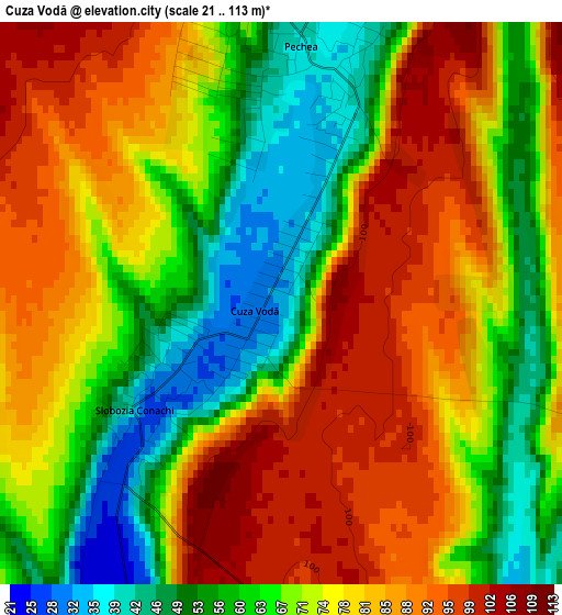
Below is the Elevation map of Cuza Vodă, which displays elevation range with different colors. Scale of the first map is from 21 to 113 m (69 to 371 ft) with average elevation of 73.5 meters (=241 ft) [note 1]
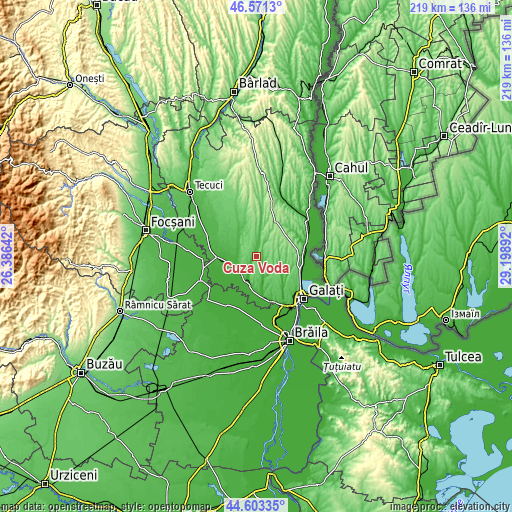
These maps also provides idea of topography and contour of this city, they are displayed at different zoom levels. More info about maps, scale and edge coordinates you can find below images.
| \ | Map #1 | Topo.Map |
| Scale [m] | 21..113 m | × |
| Scale [ft] | 69..371 ft | × |
| Average | 73.5 m = 241 ft | × |
| Width | 6.84 km = 4.3 mi | 218.8 km = 136 mi |
| Height | 6.84 km = 4.3 mi | 218.8 km = 136 mi |
| ↑Max Latitude | 45.626691° | 46.5713° |
| Latitude at center | 45.59595° | 45.59595° |
| ↓Min Latitude | 45.565192° | 44.60335° |
| ← Min Longitude | 27.748725° | 26.38642° |
| Longitude center | 27.79267° | 27.79267° |
| →Max Longitude | 27.836615° | 29.19892° |
Nearby cities:
Cities around Cuza Vodă sort by population:
• Pechea elevation 44 m
4.2 km,  7°
7°
• Tudor Vladimirescu 20 m
11.6 km,  253°
253°
• Piscu 14 m
11.6 km,  203°
203°
• Independenţa 9 m
13 km,  194°
194°
• Rediu 111 m
13.8 km, 13°
• Schela 66 m
10.8 km,  170°
170°
• Slobozia Conachi 70 m
1.6 km,  207°
207°
• Costache Negri 48 m
13 km,  332°
332°
• Hanu Conachi 21 m
15.4 km,  266°
266°
• Odaia Manolache 69 m
16.3 km,  108°
108°
• Suhurlui 67 m
15 km, 10°
• Cișmele 59 m
13.9 km,  129°
129°
Multilingual:
 En español:
Cuza Vodă elevación 35 m.
 En France:
Cuza Vodă élévation 35 m.
 Auf Deutsch:
Cuza Vodă höhe über dem Meeresspiegel ist 35 m.

Sources and notes:
- [note 1] Map square and city borders are not equal. Map elevation data is calculated only from area inside that square.
- [src 1] Elevation data from geonames database provided with same terms of usage.
- [src 2] The elevation map of Cuza Vodă is generated using elevation data from NASA's 3 arcsec (90m) resolution SRTM data.
- [src 3] Base (background) map © OpenStreetMap contributors tiles are generated by Geofabrik and OpenTopoMap.
Copyright & License:
This Cuza Vodă Elevation Map is licensed under CC BY-SA. You may reuse any part from this page, if you give a proper credit by linking to this URL:
 More info on terms of use page.