Drânceni elevation
Drânceni (Vaslui, Comuna Drânceni), Romania elevation is 32 meters and Drânceni elevation in feet is 105 ft above sea level [src 1]. Drânceni is a seat of a second-order administrative division (feature code) with elevation that is 220 meters (722 ft) smaller than average city elevation in Romania.
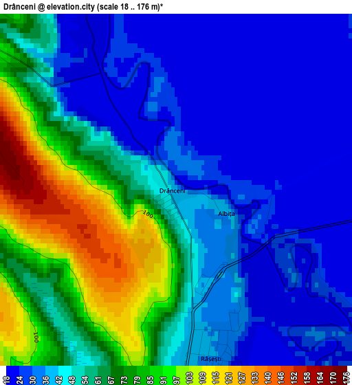
Below is the Elevation map of Drânceni, which displays elevation range with different colors. Scale of the first map is from 18 to 176 m (59 to 577 ft) with average elevation of 53 meters (=174 ft) [note 1]
These maps also provides idea of topography and contour of this city, they are displayed at different zoom levels. More info about maps, scale and edge coordinates you can find below images.
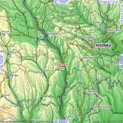
| \ | Map #1 | Topo.Map |
| Scale [m] | 18..176 m | × |
| Scale [ft] | 59..577 ft | × |
| Average | 53 m = 174 ft | × |
| Width | 6.69 km = 4.2 mi | 214.1 km = 133 mi |
| Height | 6.69 km = 4.2 mi | 214.1 km = 133 mi |
| ↑Max Latitude | 46.831533° | 47.75547° |
| Latitude at center | 46.80146° | 46.80146° |
| ↓Min Latitude | 46.77137° | 45.83022° |
| ← Min Longitude | 28.088695° | 26.72639° |
| Longitude center | 28.13264° | 28.13264° |
| →Max Longitude | 28.176585° | 29.53889° |
Nearby cities:
Cities around Drânceni sort by population:
• Duda elevation 204 m
9.1 km,  233°
233°
• Băile Drânceni 55 m
2.8 km,  299°
299°
• Cozmeşti 180 m
14.6 km,  308°
308°
• Buneşti 172 m
13.1 km,  285°
285°
• Gorban 55 m
9.3 km,  333°
333°
• Ghermănești 105 m
5 km, 308°
• Arsura 202 m
8.5 km,  278°
278°
• Râșești 34 m
3.3 km,  166°
166°
• Epureni 133 m
12.7 km,  214°
214°
• Valea Grecului 53 m
9.4 km,  194°
194°
• Pogănești 20 m
12.4 km, 167°
• Podolenii de Sus 96 m
10.9 km, 304°
Multilingual:
 En español:
Drânceni elevación 32 m.
 En France:
Drânceni élévation 32 m.


Sources and notes:
- [note 1] Map square and city borders are not equal. Map elevation data is calculated only from area inside that square.
- [src 1] Elevation data from geonames database provided with same terms of usage.
- [src 2] The elevation map of Drânceni is generated using elevation data from NASA's 3 arcsec (90m) resolution SRTM data.
- [src 3] Base (background) map © OpenStreetMap contributors tiles are generated by Geofabrik and OpenTopoMap.
Copyright & License:
This Drânceni Elevation Map is licensed under CC BY-SA. You may reuse any part from this page, if you give a proper credit by linking to this URL:
 More info on terms of use page.